Fernie Wastewater Penalty Issued by Province
July 13, 2026

Open Men
159 UNITED CYCLE TEAM United Cycle Team Open Men United Cycle Team 3:54:44.69 *** 1
108 LA RUTA La Ruta Open Men La Ruta 4:03:12.26 +8:27.57 2
71 OPUS Opus Open Men Opus 4:08:44.22 +13:59.53 3
95 100% NEW ZEALAND 100% New Zealand Open Men 100% New Zealand 4:12:31.74 +17:47.05 4
154 SCHEFFER ANDREW LTD. Scheffer Andrew Ltd. Open Men Scheffer Andrew Ltd. 4:13:36.33 +18:51.64 5
13 BIG GUY LITTLE GUY Big Guy little guy Open Men Big Guy little guy 4:15:06.23 +20:21.54 6
66 FRENETIC-VOLVO Frenetic-Volvo Open Men Frenetic-Volvo 4:17:34.21 +22:49.52 7
45 NOREFJELL CK Norefjell CK Open Men Norefjell CK 4:19:47.46 +25:02.77 8
62 VISITPA.COM VisitPA.com Open Men VisitPA.com 4:23:37.42 +28:52.73 9
112 ROCKY MOUNTAIN / EAS ports Rocky Mountain / EAs Open Men Rocky Mountain / EAs 4:24:10.75 +29:26.06 10
104 TEAM MERMAID Team Mermaid Open Men Team Mermaid 4:25:37.44 +30:52.75 11
152 SPECIALIZED/SOLO-GI Specialized/Solo-GI Open Men Specialized/Solo-GI 4:25:54.55 +31:09.86 12
84 RIDLEY’S CYCLE/ DEA dgoat Ridley’s Cycle/ Dea Open Men Ridley’s Cycle/ Dea 4:31:20.71 +36:36.02 13
101 HAMMERMANN Hammermann Open Men Hammermann 4:32:43.29 +37:58.60 14
1 ROCKY MOUNTAIN BICYC les/ Haywood Se Rocky Mountain Bicyc Open Men Rocky Mountain Bicyc 4:35:56.29 +41:11.60 15
146 MIDNIGHT SUN COFFEE Midnight Sun Coffee Open Men Midnight Sun Coffee 4:39:12.14 +44:27.45 16
81 PERFECT STRANGERS Perfect Strangers Open Men Perfect Strangers 4:39:49.64 +45:04.95 17
155 TEAM SAWTOOTH Team Sawtooth Open Men Team Sawtooth 4:40:00.25 +45:15.56 18
153 ARROWSMITH BIKES ARROWSMITH BIKES Open Men ARROWSMITH BIKES 4:42:14.16 +47:29.47 19
92 AUSTRIAN GRIZZLIES Austrian Grizzlies Open Men Austrian Grizzlies 4:46:15.52 +51:30.83 20
68 MYERS MECHANICAL Myers Mechanical Open Men Myers Mechanical 4:47:32.39 +52:47.70 21
136 COULOIR/ALIANCE SPOR ts Couloir/Aliance Spor Open Men Couloir/Aliance Spor 4:48:18.40 +53:33.71 22
51 HELLY HANSEN UK Helly Hansen UK Open Men Helly Hansen UK 4:49:42.93 +54:58.24 23
109 PEARL IZUMI-SCOTT CA nada Pearl Izumi-Scott Ca Open Men Pearl Izumi-Scott Ca 4:52:10.82 +57:26.13 24
86 DONNER PARTY Donner Party Open Men Donner Party 4:53:32.15 +58:47.46 25
31 WWW.EXTREME-ENDURANC e.com www.extreme-enduranc Open Men www.extreme-enduranc 4:56:40.27 +1:01:55.5 26
99 SCOTT – POWERBAR – M agura Scott – PowerBar – M Open Men Scott – PowerBar – M 4:59:17.06 +1:04:32.3 27
139 TEKRACING TekRacing Open Men TekRacing 5:02:13.71 +1:07:29.0 28
63 KUHL CLOTHING Kuhl Clothing Open Men Kuhl Clothing 5:03:07.15 +1:08:22.4 29
144 KLONDIKE COG CURSERS Klondike Cog Cursers Open Men Klondike Cog Cursers 5:04:02.79 +1:09:18.1 30
149 MARTIN/BENSON Martin/Benson Open Men Martin/Benson 5:04:06.40 +1:09:21.7 31
87 RELENTLESS & RUNNING free Relentless & Running Open Men Relentless & Running 5:07:30.53 +1:12:45.8 32
61 SOURCE ENDURANCE Source Endurance Open Men Source Endurance 5:07:54.19 +1:13:09.5 33
83 MAINFREIGHT MAVERICK s Mainfreight Maverick Open Men Mainfreight Maverick 5:07:55.73 +1:13:11.0 34
158 FUZZY BUNNY Fuzzy Bunny Open Men Fuzzy Bunny 5:07:56.62 +1:13:11.9 35
107 SCAT Scat Open Men Scat 5:08:15.82 +1:13:31.1 36
148 NATIONAL TEAM OF BAV aria national team of bav Open Men national team of bav 5:08:21.64 +1:13:36.9 37
103 BAGHDAD BERZECAS Baghdad Berzecas Open Men Baghdad Berzecas 5:09:53.08 +1:15:08.3 38
73 DUNHAM BROS Dunham Bros Open Men Dunham Bros 5:13:53.10 +1:19:08.4 39
24 AFGHAN HOUNDS Afghan Hounds Open Men Afghan Hounds 5:15:40.97 +1:20:56.2 40
34 ULTIMATE RIDE-AUS Ultimate Ride-AUS Open Men Ultimate Ride-AUS 5:15:54.90 +1:21:10.2 41
4 MISSOURI CATTLEMEN Missouri Cattlemen Open Men Missouri Cattlemen 5:16:40.97 +1:21:56.2 42
97 CHICKEN RUN Chicken Run Open Men Chicken Run 5:16:58.55 +1:22:13.8 43
106 DEVINCI Devinci Open Men Devinci 5:17:04.13 +1:22:19.4 44
89 CANMOREBOUND – BMO Canmorebound – BMO Open Men Canmorebound – BMO 5:17:28.13 +1:22:43.4 45
7 TEAM COBRA BEER Team Cobra Beer Open Men Team Cobra Beer 5:18:18.28 +1:23:33.5 46
27 TEAM TRINITY ROOMS Team Trinity Rooms Open Men Team Trinity Rooms 5:20:51.24 +1:26:06.5 47
54 LLIKZZUB Llikzzub Open Men Llikzzub 5:21:10.45 +1:26:25.7 48
76 POISON OAKERS Poison Oakers Open Men Poison Oakers 5:22:50.70 +1:28:06.0 49
65 TEAM GROGNARD Team Grognard Open Men Team Grognard 5:24:38.74 +1:29:54.0 50
151 CGI – BROWN BROTHERS CGI – Brown Brothers Open Men CGI – Brown Brothers 5:26:13.26 +1:31:28.5 51
48 FARM BOYS IN LYCRA Farm Boys in Lycra Open Men Farm Boys in Lycra 5:27:13.50 +1:32:28.8 52
21 HVALSOE MTB-CANYON Hvalsoe MTB-CANYON Open Men Hvalsoe MTB-CANYON 5:30:47.35 +1:36:02.6 53
33 TEAM CATAMOUNT Team Catamount Open Men Team Catamount 5:31:35.00 +1:36:50.3 54
39 TEAM BODYFIT Team Bodyfit Open Men Team Bodyfit 5:31:48.96 +1:37:04.2 55
74 LIVIN THE DREAM CANA da livin the dream cana Open Men livin the dream cana 5:34:09.95 +1:39:25.2 56
82 TEAM MELTDOWN Team Meltdown Open Men Team Meltdown 5:34:54.78 +1:40:10.0 57
69 BIG RED Big RED Open Men Big RED 5:35:40.24 +1:40:55.5 58
133 TEAM HANNIBAL´S ARMY Team Hannibal´s Army Open Men Team Hannibal´s Army 5:38:15.24 +1:43:30.5 59
79 TEAM BOOTYGRABBER Team Bootygrabber Open Men Team Bootygrabber 5:39:58.07 +1:45:13.3 60
85 LES PACHYDERMES les pachydermes Open Men les pachydermes 5:40:34.61 +1:45:49.9 61
134 CROOK’DSHANKS Crook’dShanks Open Men Crook’dShanks 5:40:53.28 +1:46:08.5 62
55 TEAM CYCLEPATH VANCO uver team cyclepath vanco Open Men team cyclepath vanco 5:41:34.69 +1:46:50.0 63
20 TEAM K2 RACING Team K2 Racing Open Men Team K2 Racing 5:41:47.16 +1:47:02.4 64
67 THE RIFLES The Rifles Open Men The Rifles 5:45:04.29 +1:50:19.6 65
23 TEAM PG / SPF 45 Team PG / SPF 45 Open Men Team PG / SPF 45 5:47:30.90 +1:52:46.2 66
105 HIGHER EDUCATION 2 Higher Education 2 Open Men Higher Education 2 5:48:05.97 +1:53:21.2 67
59 UNITED CYCLE TEAM IV United Cycle Team IV Open Men United Cycle Team IV 5:50:40.71 +1:55:56.0 68
117 READY MADE LLAMAS Ready Made Llamas Open Men Ready Made Llamas 5:58:38.69 +2:03:54.0 69
38 HOSS Hoss Open Men Hoss 5:59:44.25 +2:04:59.5 70
3 DUTCH IN THE ROCKS Dutch in the Rocks Open Men Dutch in the Rocks 6:00:30.33 +2:05:45.6 71
14 TOTAL BEASTS Total Beasts Open Men Total Beasts 6:04:03.96 +2:09:19.2 72
150 TEAM CHELSEA Team Chelsea Open Men Team Chelsea 6:04:45.40 +2:10:00.7 73
28 GRANDY Grandy Open Men Grandy 6:07:09.65 +2:12:24.9 74
18 SPINNIN’ AND GRINNIN ‘ Spinnin’ and Grinnin Open Men Spinnin’ and Grinnin 6:07:11.94 +2:12:27.2 75
30 LONDON PHOENIX London Phoenix Open Men London Phoenix 6:09:52.87 +2:15:08.1 76
70 LET’S DEUX THIS Let’s Deux This Open Men Let’s Deux This 6:10:12.07 +2:15:27.3 77
157 FLY BOYS Fly Boys Open Men Fly Boys 6:10:33.27 +2:15:48.5 78
78 STEVENS² stevens² Open Men stevens² 6:11:20.45 +2:16:35.7 79
135 BRAINCHILD/CYCLEPATH Oakv Brainchild/Cyclepath Open Men Brainchild/Cyclepath 6:13:43.79 +2:18:59.1 80
5 COMFORTABLY NUMB Comfortably Numb Open Men Comfortably Numb 6:13:51.75 +2:19:07.0 81
88 PEAKS Peaks Open Men Peaks 6:16:13.97 +2:21:29.2 82
2 BRADYGAMES/AUTOQUEST BradyGames/AutoQuest Open Men BradyGames/AutoQuest 6:18:49.99 +2:24:05.3 83
35 BIG FAT MISFIT Big Fat Misfit Open Men Big Fat Misfit 6:19:02.65 +2:24:17.9 84
90 PASSION TRAIL TEAM Passion Trail Team Open Men Passion Trail Team 6:19:10.40 +2:24:25.7 85
50 JOHN HENRY MEMORIAL Fund John Henry Memorial Open Men John Henry Memorial 6:19:48.35 +2:25:03.6 86
57 SMALL BRAINS Big Hearts Small Brains Open Men Big Hearts 6:20:02.52 +2:25:17.8 87
102 SPROCKET AND HUBS Sprocket and Hubs Open Men Sprocket and Hubs 6:21:00.17 +2:26:15.4 88
25 IRISH BEAR WRESTLING Team Irish Bear Wrestling Open Men Irish Bear Wrestling 6:22:45.98 +2:28:01.2 89
44 DEEP FRIED MARS BARS deep fried mars bars Open Men deep fried mars bars 6:23:50.96 +2:29:06.2 90
138 SIMPLY DO IT SIMply do it Open Men SIMply do it 6:24:14.59 +2:29:29.9 91
145 FURMIVALL SCULLERS Furmivall Scullers Open Men Furmivall Scullers 6:25:08.34 +2:30:23.6 92
156 TOYOTA NEVER QUIT TE am Toyota Never Quit Te Open Men Toyota Never Quit Te 6:25:15.07 +2:30:30.3 93
223 JUA KALI Jua Kali Open Men Jua Kali 6:25:37.14 +2:30:52.4 94
36 BROTHERS IN THE BACK yard Brothers in the Back Open Men Brothers in the Back 6:26:20.63 +2:31:35.9 95
22 CELTIC BIKERS Celtic Bikers Open Men Celtic Bikers 6:26:36.93 +2:31:52.2 96
12 WANDERING CHIMPS Wandering Chimps Open Men Wandering Chimps 6:36:54.00 +2:42:09.3 97
19 UNITED CYCLE V United Cycle V Open Men United Cycle V 6:40:41.78 +2:45:57.0 98
26 MISFIT PSYCLES Misfit Psycles Open Men Misfit Psycles 6:41:21.75 +2:46:37.0 99
80 RUNNINGFREE.COM Runningfree.com Open Men Runningfree.com 6:42:18.89 +2:47:34.2100
64 YEREN ASR YeRen ASR Open Men YeRen ASR 6:48:55.33 +2:54:10.6 101
29 CHAOS Chaos Open Men Chaos 6:53:11.99 +2:58:27.3 102
100 ZERIEUSA ZerieUSA Open Men ZerieUSA 6:55:09.14 +3:00:24.4 103
11 HECTOR’S HEROES Hector’s Heroes Open Men Hector’s Heroes 6:59:14.72 +3:04:30.0 104
6 PRDEL RACING Prdel Racing Open Men Prdel Racing 7:09:58.29 +3:15:13.6 105
37 TEAM TB-1 FOOT Team TB-1 Foot Open Men Team TB-1 Foot 7:14:25.14 +3:19:40.4 106
93 BIKEDRESS.DE bikedress.de Open Men bikedress.de 7:15:15.24 +3:20:30.5 107
9 SHOGANAI Shoganai Open Men Shoganai 7:16:46.57 +3:22:01.8 108
42 TRANSROOKIES Transrookies Open Men Transrookies 7:16:57.81 +3:22:13.1 109
53 TEAM ELKFORD Team Elkford Open Men Team Elkford 7:17:25.40 +3:22:40.7 110
46 THE TERRIBLE IVANS The Terrible Ivans Open Men The Terrible Ivans 7:17:55.70 +3:23:11.0 111
80+ Men
468 CENTRA PERFORMANCE Centra Performance 80+ Men Centra Performance 4:29:41.55 *** 1
414 DEADGOAT/FITZGERALDR acing Deadgoat/FitzgeraldR 80+ Men Deadgoat/FitzgeraldR 4:33:56.84 +4:15.29 2
432 THE RIDERS OF GRAYMO nt The Riders of Graymo 80+ Men The Riders of Graymo 4:35:26.55 +5:45.00 3
401 TEAM TAMARACK RESORT Idah Team Tamarack Resort 80+ Men Team Tamarack Resort 4:38:29.87 +8:48.32 4
415 DEADGOAT RACING Deadgoat Racing 80+ Men Deadgoat Racing 4:45:59.92 +16:18.37 5
489 CAPITOL SUBARU CYCLI ng Capitol Subaru Cycli 80+ Men Capitol Subaru Cycli 4:47:47.74 +18:06.19 6
457 MAKGADIKGADI CUBS Makgadikgadi Cubs 80+ Men Makgadikgadi Cubs 4:52:34.95 +22:53.40 7
406 GONGSTERS GONGSTERS 80+ Men GONGSTERS 4:58:42.45 +29:00.90 8
437 PEDALS WITHOUT A CAU se Pedals Without a Cau 80+ Men Pedals Without a Cau 5:03:20.46 +33:38.91 9
441 FIGHTIN’ BOBAS / GIA nni Fightin’ Bobas / Gia 80+ Men Fightin’ Bobas / Gia 5:06:01.16 +36:19.61 10
413 BAJA RACERS Baja Racers 80+ Men Baja Racers 5:06:17.08 +36:35.53 11
421 STEED CYCLES/DARK HO rse Racing Steed Cycles/Dark Ho 80+ Men Steed Cycles/Dark Ho 5:06:33.85 +36:52.30 12
476 TRANSROCKY HORROR SH ow TransRocky Horror Sh 80+ Men TransRocky Horror Sh 5:08:38.32 +38:56.77 13
424 SCHMOE RACING Schmoe Racing 80+ Men Schmoe Racing 5:08:40.32 +38:58.77 14
488 MUDMEN Mudmen 80+ Men Mudmen 5:08:43.06 +39:01.51 15
472 TEAM WEVA / BIONICON TEAM WEVA / BIONICON 80+ Men TEAM WEVA / BIONICON 5:08:48.47 +39:06.92 16
463 TEAM PEDAL / KONA Team Pedal / Kona 80+ Men Team Pedal / Kona 5:09:42.00 +40:00.45 17
485 STARSHIP TROOPERS Starship Troopers 80+ Men Starship Troopers 5:15:18.86 +45:37.31 18
444 LITTLEMAN SPORTING C lub LittleMan Sporting C 80+ Men LittleMan Sporting C 5:16:06.57 +46:25.02 19
462 ASTORIA DE’D DOGS Astoria De’d Dogs 80+ Men Astoria De’d Dogs 5:18:03.63 +48:22.08 20
425 DEADGOAT RACING / BO w Cyc Deadgoat Racing / Bo 80+ Men Deadgoat Racing / Bo 5:19:35.05 +49:53.50 21
436 GO BUDDY GO Go Buddy Go 80+ Men Go Buddy Go 5:26:48.70 +57:07.15 22
454 HARDLINE Hardline 80+ Men Hardline 5:27:18.51 +57:36.96 23
459 UNITED CYCLE TEAM II I United Cycle Team II 80+ Men United Cycle Team II 5:29:22.61 +59:41.06 24
402 PAIN IN THE KOOTANIE s Pain in the Kootanie 80+ Men Pain in the Kootanie 5:29:53.78 +1:00:12.2 25
440 2XU 2XU 80+ Men 2XU 5:31:52.03 +1:02:10.4 26
461 LITTLE LEBOWSKI URBA n Ach Little Lebowski Urba 80+ Men Little Lebowski Urba 5:33:29.03 +1:03:47.4 27
486 DREAMCATCHER CHALETS DreamCatcher Chalets 80+ Men DreamCatcher Chalets 5:36:02.96 +1:06:21.4 28
491 KF-DYNA kf-dyna 80+ Men kf-dyna 5:36:17.89 +1:06:36.3 29
407 TEAM MILO Team Milo 80+ Men Team Milo 5:37:45.07 +1:08:03.5 30
411 GLENBURNIE TRAILS Glenburnie Trails 80+ Men Glenburnie Trails 5:39:22.77 +1:09:41.2 31
460 MISFIT PSYCLES MISFIT PSYCLES 80+ Men MISFIT PSYCLES 5:40:34.83 +1:10:53.2 32
456 FERNIE WOLVERINES Fernie Wolverines 80+ Men Fernie Wolverines 5:41:53.32 +1:12:11.7 33
434 FERNIE GRIZZLIES Fernie Grizzlies 80+ Men Fernie Grizzlies 5:46:11.75 +1:16:30.2 34
451 NUCKING FUTS Nucking Futs 80+ Men Nucking Futs 5:47:56.95 +1:18:15.4 35
442 IDAHO TWO WHEELS VER tical Idaho Two Wheels Ver 80+ Men Idaho Two Wheels Ver 5:48:11.79 +1:18:30.2 36
430 W&R W&R 80+ Men W&R 5:48:48.39 +1:19:06.8 37
426 OUT OF AFRICA OUT OF AFRICA 80+ Men OUT OF AFRICA 5:49:47.41 +1:20:05.8 38
470 SWISS ANIMALS Swiss Animals 80+ Men Swiss Animals 5:50:12.53 +1:20:30.9 39
471 BIG SUGAR Big Sugar 80+ Men Big Sugar 5:52:03.15 +1:22:21.6 40
445 TEAM LEMONADE SPARKL e Team Lemonade Sparkl 80+ Men Team Lemonade Sparkl 5:53:48.83 +1:24:07.2 41
409 LONDON DYNAMO London Dynamo 80+ Men London Dynamo 5:56:22.31 +1:26:40.7 42
464 MEX Y CAN Mex y Can 80+ Men Mex y Can 5:57:03.79 +1:27:22.2 43
417 TEAM HUNSRüCK Team Hunsrück 80+ Men Team Hunsrück 5:57:11.33 +1:27:29.7 44
477 ROCKY MOUNTAIN PULSK iller Rocky Mountain Pulsk 80+ Men Rocky Mountain Pulsk 5:57:52.72 +1:28:11.1 45
484 SPORTMIND Sportmind 80+ Men Sportmind 6:00:08.13 +1:30:26.5 46
455 KANIMAMBO KANIMAMBO 80+ Men KANIMAMBO 6:01:06.76 +1:31:25.2 47
412 CYCLEPATH OAKVILLE – N4S Cyclepath Oakville – 80+ Men Cyclepath Oakville – 6:01:09.76 +1:31:28.2 48
416 WISH YOU! Wish You! 80+ Men Wish You! 6:04:40.39 +1:34:58.8 49
474 OLD & SLOW Old & Slow 80+ Men Old & Slow 6:08:54.59 +1:39:13.0 50
446 RB SQUARED RB Squared 80+ Men RB Squared 6:09:10.87 +1:39:29.3 51
469 TEAM SYKLISTEN Team Syklisten 80+ Men Team Syklisten 6:14:39.01 +1:44:57.4 52
438 VELOEPIC VeloEpic 80+ Men VeloEpic 6:19:45.07 +1:50:03.5 53
420 ROASTED SALTY NUTS Roasted Salty Nuts 80+ Men Roasted Salty Nuts 6:21:39.45 +1:51:57.9 54
465 CYCLEPATH CALGARY Cyclepath Calgary 80+ Men Cyclepath Calgary 6:24:18.80 +1:54:37.2 55
453 CYCLELOGICAL PROBLEM s Cyclelogical Problem 80+ Men Cyclelogical Problem 6:24:21.74 +1:54:40.1 56
466 MUD LIFE CRISIS Mud Life Crisis 80+ Men Mud Life Crisis 6:26:47.18 +1:57:05.6 57
490 SITKA DEVELOPMENTS Sitka Developments 80+ Men Sitka Developments 6:29:25.52 +1:59:43.9 58
467 TEAM LABORA Team Labora 80+ Men Team Labora 6:29:51.01 +2:00:09.4 59
448 PAINTED SHORTS Painted Shorts 80+ Men Painted Shorts 6:35:41.86 +2:06:00.3 60
429 KARMA ROCKS THE ROCK ies Karma Rocks the Rock 80+ Men Karma Rocks the Rock 6:46:04.94 +2:16:23.3 61
428 SHUGGMIESTER Shuggmiester 80+ Men Shuggmiester 6:53:19.84 +2:23:38.2 62
479 ONE LESS CAR One Less Car 80+ Men One Less Car 6:55:44.67 +2:26:03.1 63
449 BRAZILIAN BOYS Brazilian Boys 80+ Men Brazilian Boys 6:56:05.35 +2:26:23.8 64
473 FLYIN 40’S Flyin 40’s 80+ Men Flyin 40’s 7:09:29.81 +2:39:48.2 65
433 MRC MRC 80+ Men MRC 7:16:43.86 +2:47:02.3 66
Open Mixed
345 FRONTRUNNERS–KONA Frontrunners–KONA Open Mixed Frontrunners–KONA 4:26:46.91 *** 1
301 SHOAIR/ROCKANDROAD/X fusio shoair/rockandroad/x Open Mixed shoair/rockandroad/x 4:46:23.42 +19:36.51 2
341 WILSON MOUNTAINSPORT s/EAS Wilson MountainSport Open Mixed Wilson MountainSport 4:49:24.27 +22:37.36 3
323 ERGALL Ergall Open Mixed Ergall 4:55:40.72 +28:53.81 4
344 FEARLESS BEAVERS Fearless Beavers Open Mixed Fearless Beavers 4:56:00.92 +29:14.01 5
315 SCHMOE RACING TOO Schmoe Racing too Open Mixed Schmoe Racing too 5:04:05.85 +37:18.94 6
314 TEAM SCANDAL Team Scandal Open Mixed Team Scandal 5:09:16.62 +42:29.71 7
305 LESSARD – CYCLE LAMB erts Lessard – Cycle Lamb Open Mixed Lessard – Cycle Lamb 5:13:56.10 +47:09.19 8
342 TEAM MOBI Team MOBI Open Mixed Team MOBI 5:16:36.02 +49:49.11 9
321 TNT TnT Open Mixed TnT 5:18:18.87 +51:31.96 10
318 LET’S JUST RIDE let’s just ride Open Mixed let’s just ride 5:26:30.91 +59:44.00 11
311 AMASHOVA amashova Open Mixed amashova 5:47:29.71 +1:20:42.8 12
304 AURELIAN ECUADOR AURELIAN ECUADOR Open Mixed AURELIAN ECUADOR 5:48:18.13 +1:21:31.2 13
338 TEAM BERRY Team Berry Open Mixed Team Berry 6:09:09.22 +1:42:22.3 14
322 WEST POINT/STEED CYC les West Point/Steed Cyc Open Mixed West Point/Steed Cyc 6:11:21.24 +1:44:34.3 15
307 RAM RAM Open Mixed RAM 6:12:55.65 +1:46:08.7 16
308 SCAPEGOAT RACING ScapeGoat Racing Open Mixed ScapeGoat Racing 6:19:36.53 +1:52:49.6 17
309 BLITZPRINT BlitzPrint Open Mixed BlitzPrint 6:26:39.45 +1:59:52.5 18
303 TEAM OUTLYNE TEAM OUTLYNE Open Mixed TEAM OUTLYNE 6:30:58.24 +2:04:11.3 19
327 FAT TIRED Fat Tired Open Mixed Fat Tired 6:31:31.66 +2:04:44.7 20
319 TEAM GOGO Team GoGo Open Mixed Team GoGo 6:49:56.14 +2:23:09.2 21
320 DEKIRU DEKIRU Open Mixed DEKIRU 7:05:22.32 +2:38:35.4 22
Open Women
205 CANIWI GIRLS CANIWI GIRLS Open Women CANIWI GIRLS 5:08:45.27 *** 1
328 TREK VW – GIANT Trek VW – Giant Open Women Trek VW – Giant 5:16:25.79 +7:40.52 2
207 MINX/EXTREME ENDURAN ce Minx/Extreme Enduran Open Women Minx/Extreme Enduran 6:06:08.13 +57:22.86 3
209 TEAM HILLY HELL Team Hilly Hell Open Women Team Hilly Hell 6:23:06.31 +1:14:21.0 4
206 GUIDI-UP Guidi-up Open Women Guidi-up 6:24:49.06 +1:16:03.7 5
204 WE’RE 40! We’re 40! Open Women We’re 40! 6:46:02.42 +1:37:17.1 6
80+ Mixed
608 KONA/LE PéDALIER Kona/Le pédalier 80+ Mixed Kona/Le pédalier 4:56:33.29 *** 1
604 DEADGOAT RACING Deadgoat Racing 80+ Mixed Deadgoat Racing 4:56:39.05 5.76 2
601 LOS BANDIDOS / GHOST Team Los Bandidos / Ghost 80+ Mixed Los Bandidos / Ghost 5:57:26.35 +1:00:53.0 3
609 EDGEHEADS Edgeheads 80+ Mixed Edgeheads 6:11:36.14 +1:15:02.8 4
611 GEMINI GOATS Gemini Goats 80+ Mixed Gemini Goats 6:30:34.15 +1:34:00.8 5
614 PEBBLES & BAM-BAM Pebbles & Bam-Bam 80+ Mixed Pebbles & Bam-Bam 6:39:09.40 +1:42:36.1 6
624 OVER THE HILL Over the Hill 80+ Mixed Over the Hill 6:44:01.23 +1:47:27.9 7
615 CHIPOLTLE TITUS/MASH oogs chipoltle titus/mash 80+ Mixed chipoltle titus/mash 6:54:24.16 +1:57:50.8 8
100+ Open
705 SYNGENTA PRAIRIE BOY s Syngenta Prairie Boy 100+ Open Syngenta Prairie Boy 4:31:20.51 *** 1
709 ZOOTALLURES Zootallures 100+ Open Zootallures 4:37:18.25 +5:57.74 2
722 TEAM R.A.C.E. / KAMI kaze Team R.A.C.E. / Kami 100+ Open Team R.A.C.E. / Kami 5:08:05.42 +36:44.91 3
728 TEAM KIWI Team Kiwi 100+ Open Team Kiwi 5:25:57.73 +54:37.22 4
717 SüDTIROL Südtirol 100+ Open Südtirol 5:36:38.09 +1:05:17.5 5
721 FERNIE GOATS Fernie Goats 100+ Open Fernie Goats 6:11:32.79 +1:40:12.2 6
701 SUPER ELLIOTT Super Elliott 100+ Open Super Elliott 6:15:48.10 +1:44:27.5 7
712 MCBIKE RIDERS mcbike riders 100+ Open mcbike riders 6:21:46.43 +1:50:25.9 8
710 ROAD RASH Road Rash 100+ Open Road Rash 6:24:16.41 +1:52:55.9 9
708 FIDAS Fidas 100+ Open Fidas 6:27:31.49 +1:56:10.9 10
703 TEAM VELOCITY Team Velocity 100+ Open Team Velocity 6:29:28.56 +1:58:08.0 11
718 TOUGH LUMBER Tough Lumber 100+ Open Tough Lumber 6:33:57.23 +2:02:36.7 12
706 CANMORE BOYZ Canmore Boyz 100+ Open Canmore Boyz 6:42:13.12 +2:10:52.6 13
715 WHYNOT WHYNOT 100+ Open WHYNOT 6:46:25.37 +2:15:04.8 14
719 TEAM TWIN-100 Team Twin-100 100+ Open Team Twin-100 6:47:56.56 +2:16:36.0 15
732 TEAM HOLLAND 2 team holland 2 100+ Open team holland 2 6:49:58.24 +2:18:37.7 16
729 LE SOPRANO BIKE TEAM Le Soprano Bike Team 100+ Open Le Soprano Bike Team 6:59:10.23 +2:27:49.7 17
Unclassified
201 RAVEN (SOLO) Raven (Solo) Unclassified Raven (Solo) 4:39:55.46 *** 1
602 ALPINE SUN AND SHOWE r (Solo) alpine sun and showe Unclassified alpine sun and showe 6:46:46.16 +2:06:50.7 2
Invermere to Nipika Mountain Resort
60km/1302m climbing
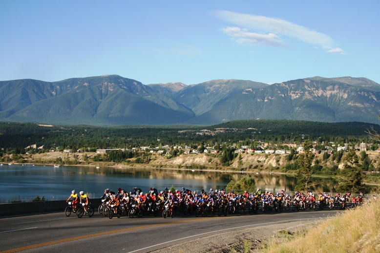
After a late-afternoon windstorm which blew through Invermere on Sunday, flipping tents and wreaking havoc in the rider village, conditions settled down for the evening and riders were treated to perfect cool mountain night to rest up for the second day of the TransRockies Challenge.
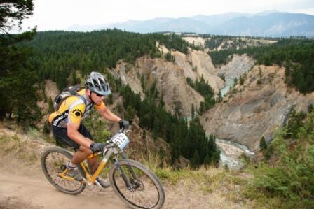
Leaving Invermere in a rolling closure provided by the local Royal Canadian Mounted Police, riders were launched into race mode after the first 3 neutralized km and the attacks came fast and furious as the top teams tested each other to see who had recovered after the first day’s effort. Riders rode uphill for the next 20km climbing to the top of Bear Creek, first via logging road, then on some steep and technical jeep trails. The majority of the last 40km was raced on singletrack, varying from raw and precarious trails down from Bear Creek into the Kootenay River Valley, finishing on the buffed and perfect trails of Nipika Mountain Resort.
Day 1’s winners Roddi Legga and Tim Heemskerk or United Cycles looked to do some more damage to their rivals and launched an early attack which again shed all but the top group of teams. As they ground to the top, they managed to escape from the rest of the field and kept the pressure on, surviving a late race scare when Legga had a slow leak which wouldn’t reseal. He ended up riding the last 5 km on a flat until they crossed the finish in 3:08:46 ahead of second place by 5 ½ minutes. Their overall lead in GC is roughly 10 minutes and they’re starting to establish the type of gap necessary to carry through the inevitable mechanicals which they had today and which are always a part of the TransRockies epic.
Behind them Team Rocky Mountain EA Sports and Team La Ruta were waging a UFC style battle for second. While Team La Ruta established a lead over the climb, the two Matts—Green and Hadley—of Team Rocky Mountain EA Sports used their superior downhill skills to catch them by the bottom of the Bear Creek descent. After Green broke his chain, the battle seemed to be over but La Ruta took a wrong turn and went off course for roughly five minutes allowing Green and Hadley to grab second place on the day in 3:14:16, the Ticos crossed the line in 3:17:50 and are now just over 3 minutes adrift of second place on GC.

The most competitive racing so far has been in the Open Women’s category with the top three teams coming in less than two minutes apart during stage 1 and battling closely again in stage 2. By the end, though Sue Haywood and Hillary Harrison of Team Giant/Trek Bicycles applied the pressure as Harrison began to felt better and they surged to a three minute gap by the time they crossed the line in 4:11:03. Behind them the Team Canwi Girls (Jenny Hillman/Jo Turnbull) stayed close and the British duo of Fi Spotswood and Meggie Bichard came in shortly after to keep the three-way battle alive.
One category which shows no sign of being competitive is the Open Mixed category in which the pair of Wendy Simms , one of Canada’s premiere women’s mountain bikers and her partner Norm Thibault, both based in beautiful Nanaimo, British Columbia, have put on a clinic with consecutive crushing wins and now lead the GC by over 32 minutes. .
As the sun set in idyllic Nipika Mountain Resort, all the riders bar a couple of injuries are through the first day nerves and settling into the eat, rest and ride rhythm of a stage race. With no cellphone coverage and very limited access to the outside world for the majority of the route, the hundreds of motivated type-A personalities who choose to take on this type of event are relearning how to just kick back and conserve energy for the next day’s riding, which in this case covers as many KM as the first two days combined . . .
Place Plate Team Team Leader NAT Team Member NAT Stage Time Penalties Total Time
100+ Open Gender
1 709 Zootallures AMYOT, François CDN AUCLAIR, Daniel CDN 03:38:36.38 00:00:00.00 03:38:36.38
2 705 Syngenta Prairie Boys BENSON, Bill CDN SISSONS, Don CDN 03:53:01.26 00:00:00.00 03:53:01.26
3 722 Team R.A.C.E. / Kamikaze GORDON, Hamish CDN VARGA, Steve CDN 03:58:48.52 00:00:00.00 03:58:48.52
4 728 Team Kiwi MADDEN, Pete NZL WILSON, Steve NZL 04:19:48.73 00:00:00.00 04:19:48.73
5 720 Couloir, RBCDS,Cannondale COWAN, Joey CDN MOE, Roy CDN 04:31:00.49 00:00:00.00 04:31:00.49
6 717 Südtirol GIACOMUZZI, Zenone ITA GRUENER, Michael ITA 04:44:58.40 00:00:00.00 04:44:58.40
7 701 Super Elliott PARKER, Simon CDN BURKE, Clive CDN 04:48:12.81 00:00:00.00 04:48:12.81
8 708 Fidas THOMAS, Cam CDN FIDLER, Derek CDN 04:58:44.24 00:00:00.00 04:58:44.24
9 721 Fernie Goats GILMAR, Pat CDN CLARK, Ron CDN 05:04:06.94 00:00:00.00 05:04:06.94
10 719 Team Twin-100 ECKERSLEY, David GBR ECKERSLEY, Ronald CDN 05:11:26.21 00:00:00.00 05:11:26.21
11 710 Road Rash WURM, Robert USA DUNN, John USA 05:12:20.32 00:00:00.00 05:12:20.32
12 715 WHYNOT SIZEMORE, Peter USA FACKLER, Blair USA 05:15:08.59 00:00:00.00 05:15:08.59
13 718 Tough Lumber PELLETIER, Gary CDN HALPRIN, Marty CDN 05:17:14.01 00:00:00.00 05:17:14.01
14 716 THIS 2 SHALL PASS COLLINS, Tom CDN DAVIDSON, Les CDN 05:17:30.24 00:00:00.00 05:17:30.24
15 712 mcbike riders STEWART, David CDN MULLER, Willie CDN 05:18:56.86 00:00:00.00 05:18:56.86
16 703 Team Velocity SARTISSON, Dieter CDN SPENCER, Ron CDN 05:20:25.32 00:00:00.00 05:20:25.32
17 706 Canmore Boyz RUBENS, Clive CDN ROGINSKI, Peter CDN 05:23:29.35 00:00:00.00 05:23:29.35
18 707 Rubber Side Down MOROZ, Dave CDN STRILCHUK, Russ CDN 05:40:52.80 00:00:00.00 05:40:52.80
19 732 team holland 2 VAN DER VELDEN, Peter NED CASTELEIJN, Gerard NED 05:46:38.92 00:00:00.00 05:46:38.92
20 704 Ultracats INNES, David USA BARRETT, Robert USA 05:51:53.23 00:00:00.00 05:51:53.23
21 729 Le Soprano Bike Team MUEHLBAUER, Alex GER KLIER, Andreas GER 05:54:04.49 00:00:00.00 05:54:04.49
22 711 Too Much Fun LAWRENCE, Gord CDN NESTER, Blaine CDN 06:08:53.75 00:00:00.00 06:08:53.75
23 714 Boulevardiers De La Buisson MACKINNON, Russell CDN HOMER, John CDN 06:20:00.51 00:00:00.00 06:20:00.51
24 702 Woodbury WOODBURY, Richard USA WOODBURY, Laurie USA 08:20:19.59 00:00:00.00 08:20:19.59
80+ Men
1 414 Deadgoat/FitzgeraldRacing BREZSNYAK, Tim CDN PIKER, Mike USA 03:47:22.62 00:00:00.00 03:47:22.62
2 410 Gyldne Tider HOEGDEN, Staale NOR SIREVAAG, Terje NOR 03:47:24.88 00:00:00.00 03:47:24.88
3 415 Deadgoat Racing RODDY, Edward CDN DOYLE, Pat CDN 03:47:49.37 00:00:00.00 03:47:49.37
4 468 Centra Performance ERIKSEN, Christian Stabell NOR SILSETH, Ole kristian NOR 03:48:32.06 00:00:00.00 03:48:32.06
5 401 Team Tamarack Resort Idah GOULD, Jon USA WHITE, Scott USA 03:49:28.05 00:00:00.00 03:49:28.05
6 489 Capitol Subaru Cycling PLEWS, Evan USA YENNE, Steve USA 03:54:02.06 00:00:00.00 03:54:02.06
7 432 The Riders of Graymont CAVALIERE, Mike CDN MAGEE, Stan CDN 03:56:10.00 00:00:00.00 03:56:10.00
8 463 Team Pedal / Kona NEWITT, Paul CDN IRVINE, Dean CDN 04:00:02.17 00:00:00.00 04:00:02.17
9 457 Makgadikgadi Cubs VAN ROOYEN, Pieter USA OERTEL, George RSA 04:04:27.20 00:00:00.00 04:04:27.20
10 441 Fightin’ Bobas / Gianni WALKER, Erin USA HARTING, Dan USA 04:05:54.85 00:00:00.00 04:05:54.85
11 406 GONGSTERS WATSON, Robert AUS LENNOX, Ryan AUS 04:09:03.25 00:00:00.00 04:09:03.25
12 413 Baja Racers BUSHNELL, Trever USA MACFARLAND, Art USA 04:10:48.02 00:00:00.00 04:10:48.02
13 476 TransRocky Horror Show DONNELLY, Paul GBR JACKSON, Andrew GBR 04:12:11.42 00:00:00.00 04:12:11.42
14 421 Steed Cycles/Dark Horse Racing RAMSDEN, John CDN STONE, Trevor CDN 04:12:18.72 00:00:00.00 04:12:18.72
15 437 Pedals Without a Cause MEKECHUK, Darryl CDN LIPKOV, Yuri CDN 04:13:11.76 00:00:00.00 04:13:11.76
16 424 Schmoe Racing WALSH, Steve CDN WALSH, Kevin CDN 04:14:21.91 00:00:00.00 04:14:21.91
17 462 Astoria De’d Dogs AUFSCHNAITER, Andy CDN ANDREW, George CDN 04:14:34.67 00:00:00.00 04:14:34.67
18 425 Deadgoat Racing / Bow Cyc MCCUAIG, Gerry CDN MURRAY, Lloyd CDN 04:15:37.41 00:00:00.00 04:15:37.41
19 485 Starship Troopers PAULY, Klaus GER KEMSIES, Ingo GER 04:18:45.60 00:00:00.00 04:18:45.60
20 444 LittleMan Sporting Club JONES, Geoff USA WITTHOFF, Scott W. USA 04:19:32.92 00:00:00.00 04:19:32.92
21 488 Mudmen EBBERN, Tom CDN JONES, Darrell CDN 04:19:36.99 00:00:00.00 04:19:36.99
22 454 Hardline POCHAY, Brad CDN DORENBOS, Dirk CDN 04:20:23.77 00:00:00.00 04:20:23.77
23 472 TEAM WEVA / BIONICON BREU, Alfons GER ZAURITZ, Wolfgan GER 04:22:44.68 00:00:00.00 04:22:44.68
24 440 2XU CADIEUX, Kevin USA POLLORENO, Lance USA 04:28:05.20 00:00:00.00 04:28:05.20
25 459 United Cycle Team III POMBERT, Trevor CDN CLEMENS, Roger CDN 04:29:45.92 00:00:00.00 04:29:45.92
26 442 Idaho Two Wheels Vertical TAYLOR, Shawn USA LAMPHIER, Tom USA 04:34:41.92 00:00:00.00 04:34:41.92
27 434 Fernie Grizzlies SOMBROWSKI, Arthur CDN MORGAN, Brendan CDN 04:35:32.51 00:00:00.00 04:35:32.51
28 417 Team Hunsrück HENN, Thomas GER VOLLRATH, Werner GER 04:36:49.11 00:00:00.00 04:36:49.11
29 407 Team Milo GRAY, Antony GBR TRILL, Brian GBR 04:40:18.42 00:00:00.00 04:40:18.42
30 436 Go Buddy Go LEEPER, Mark HNK THOMSON, Andrew HNK 04:41:38.22 00:00:00.00 04:41:38.22
31 430 Mountain View USKOSKY, Nathan USA ROBSON, Rob USA 04:43:10.02 00:00:00.00 04:43:10.02
32 486 DreamCatcher Chalets HARRIS, Andy CDN THOMPSON, Greg CDN 04:44:08.88 00:00:00.00 04:44:08.88
33 470 Swiss Animals SCHAER, Lothar SUI ROETHLISBERGER, Andy SUI 04:45:59.75 00:00:00.00 04:45:59.75
34 461 Little Lebowski Urban Ach KELLEY, Jeff USA KELLEY, JIm USA 04:46:16.96 00:00:00.00 04:46:16.96
35 460 MISFIT PSYCLES KEILLER, Peter CDN CRANWELL, Michael CDN 04:46:44.28 00:00:00.00 04:46:44.28
36 467 Team Labora MOOK, Greg GBR WYNN, Mark GBR 04:47:18.42 00:00:00.00 04:47:18.42
37 456 Fernie Wolverines STAPLIN, Sean CDN LOEWEN, Todd CDN 04:48:18.07 00:00:00.00 04:48:18.07
38 402 Pain in the Kootanies BURWASH, Dave CDN GIRVIN, Tim CDN 04:48:24.73 00:00:00.00 04:48:24.73
39 445 Team Lemonade Sparkle WILSON, Richard GBR BAUM, Gary GBR 04:48:40.62 00:00:00.00 04:48:40.62
40 464 Mex y Can BAKER, Jim CDN DATTOLI, Armando MEX 04:48:41.11 00:00:00.00 04:48:41.11
41 446 RB Squared BESSETTE, Robert CDN BOURBONNIERE, Richard CDN 04:49:26.69 00:00:00.00 04:49:26.69
42 411 Glenburnie Trails SNYDER, Grant CDN SANGERS, Rob CDN 04:50:00.47 00:00:00.00 04:50:00.47
43 420 Roasted Salty Nuts DAVIES, Richard CDN MACDOWELL, Dave CDN 04:50:17.17 00:00:00.00 04:50:17.17
44 438 VeloEpic NORMAND, Bruno CDN MULLER, Stefan CDN 04:51:15.90 00:00:00.00 04:51:15.90
45 416 Wish You! KELLER, Don USA HARGROVE, Sebastian USA 04:51:47.86 00:00:00.00 04:51:47.86
46 451 Nucking Futs SOKOLOVIC, Oggie CDN IRWIN, James CDN 04:54:46.97 00:00:00.00 04:54:46.97
47 477 Rocky Mountain Pulskiller DENFELD, Christian GER SCHUCKHARDT, Frank GER 04:55:24.45 00:00:00.00 04:55:24.45
48 426 OUT OF AFRICA SWART, BEN RSA VAN NIEUWENHUIZEN, Tjaart RSA 04:56:38.79 00:00:00.00 04:56:38.79
49 469 Team Syklisten TURNER, Gary Bruce NOR TERNSTEN, Per Oskar jr. NOR 04:58:05.15 00:00:00.00 04:58:05.15
50 412 Cyclepath Oakville – N4S SHIKAZE, Jeff CDN SHIKAZE, Greg CDN 05:00:23.30 00:00:00.00 05:00:23.30
51 474 Old & Slow BORNEO, Michael USA QUINLAN, Steve USA 05:04:28.76 00:00:00.00 05:04:28.76
52 465 Cyclepath Calgary SWENSON, Steve CDN SMAGGUS, Dennis CDN 05:08:31.35 00:00:00.00 05:08:31.35
53 433 MRC SCOTT, Jeff CDN WOLFE, Travis CDN 05:08:59.59 00:00:00.00 05:08:59.59
54 455 KANIMAMBO STEYN, Charles RSA STEYN, Charles jnr RSA 05:09:04.54 00:00:00.00 05:09:04.54
55 409 London Dynamo GILBERT, William GBR WARD, Chris GBR 05:09:54.43 00:00:00.00 05:09:54.43
56 429 Karma Rocks the Rockies MCALLISTER, Dale CDN MICHIENZI, Larry OMN 05:12:16.86 00:00:00.00 05:12:16.86
57 484 Sportmind SCOTT, Ashley GBR WILKINSON, Nigel GBR 05:13:33.99 00:00:00.00 05:13:33.99
58 471 Big Sugar KELLY, Robert CDN MCKAGUE, jeff CDN 05:14:56.51 00:00:00.00 05:14:56.51
59 448 Painted Shorts O’SHANNASSY, John CDN LOEWEN, Brad CDN 05:17:34.40 00:00:00.00 05:17:34.40
60 490 Sitka Developments ROSS, Fraser CDN BARTLETT, Craig CDN 05:19:32.81 00:00:00.00 05:19:32.81
61 466 Mud Life Crisis O’NEILL, Dave CDN HARRIS, Kevin CDN 05:20:03.04 00:00:00.00 05:20:03.04
62 453 Cyclelogical Problems GRINSTEAD, Jason USA HANDY, Chris USA 05:22:13.35 00:00:00.00 05:22:13.35
63 408 St James Connection SNIVELY, Aaron CDN RAVNAAS, Eric CDN 05:27:20.93 00:00:00.00 05:27:20.93
64 473 Flyin 40’s DODDS, Keith CDN HIDDINK, Alex CDN 05:31:51.06 00:00:00.00 05:31:51.06
65 450 NAFI DU PLESSIS, Gert CDN ALLEN, Christopher CDN 05:34:21.81 00:00:00.00 05:34:21.81
66 449 Brazilian Boys MELO, Ivam BRZ GONCALVES, Mauricio BRZ 05:35:06.72 00:00:00.00 05:35:06.72
67 419 Num Nutz KNOX, David GBR BOULT, Darrell GBR 05:38:11.23 00:00:00.00 05:38:11.23
68 428 Shuggmiester SHUGG, Jeff CDN SHUGG, Keith AUS 05:40:51.84 00:00:00.00 05:40:51.84
69 423 Hart Attak HART, Peter GBR HART, John GBR 05:43:16.19 00:00:00.00 05:43:16.19
70 443 Racing Snails HELER, Nir CDN CARTER, Mike CDN 05:43:27.24 00:00:00.00 05:43:27.24
71 487 Team Holland 1 NIEUWERTH, Erik NED VAN DER VELDEN, Aad NED 05:51:23.68 00:00:00.00 05:51:23.68
72 478 PelotonTwo GB DALLIMORE, Tony GBR YATES, Mike GBR 05:54:51.20 00:00:00.00 05:54:51.20
73 479 One Less Car GLASS, Michael USA NEUMANN, Mark USA 05:55:55.08 00:00:00.00 05:55:55.08
74 422 Square Wheels HOLLIDAY, Kevin GBR SHAW, Rob GBR 05:58:17.30 00:00:00.00 05:58:17.30
75 452 Garden City Trailblazers REBOLINI, Carlo USA HEEDLES, Mike USA 05:59:30.61 00:00:00.00 05:59:30.61
76 427 Nickel Minors DUNLEAVY, Keith GBR REECE, Steve GBR 06:08:17.56 00:00:00.00 06:08:17.56
77 404 SABWAMP CUNNINGHAM, RICK GBR KANE, STUART AUS 06:15:38.48 00:00:00.00 06:15:38.48
78 405 Tail Gunners WRAY, Dan CDN ARAPAKIS, Lake OMN 06:16:44.14 00:00:00.00 06:16:44.14
79 447 Caution: Frequent Stops STAIB, Ted USA CLOUGH, Randy USA 06:18:50.63 00:00:00.00 06:18:50.63
80 475 McZee ZYMOWSKI, Michael USA MCDONALD, Larry USA 06:19:13.13 00:00:00.00 06:19:13.13
81 418 the jaffamen KUJAWA, Philip GBR THOMAS, JASON GBR 06:24:02.99 00:00:00.00 06:24:02.99
82 435 ROOKIES KOEN, CHRISTO CDN HANES, KEVIN CDN 06:51:50.85 00:00:00.00 06:51:50.85
83 491 kf-dyna HENDERSON, Peter CDN EVANS, Keith CDN 07:20:23.19 00:00:00.00 07:20:23.19
80+ Mixed
1 608 Kona/Le pédalier MORNEAU, Gilles CDN CANTIN, Isabelle CDN 04:06:55.84 00:00:00.00 04:06:55.84
2 604 Deadgoat Racing GRAJCZYK, Trish CDN FORD, Dave CDN 04:10:20.30 00:00:00.00 04:10:20.30
3 611 Gemini Goats GREEN, Linda CDN OCONNELL, Brendan CDN 05:09:57.45 00:00:00.00 05:09:57.45
4 615 chipoltle titus/mashoogs PARDOE, Kim USA MIRIPOL, Aaron USA 05:16:22.77 00:00:00.00 05:16:22.77
5 601 Los Bandidos / Ghost Team KIESSLING, Gerhard GER LOEFFLER, Kerstin GER 05:16:51.13 00:00:00.00 05:16:51.13
6 614 Pebbles & Bam-Bam ROGOSCHEWSKY, Annie CDN HARBINSON, Evan CDN 05:26:10.35 00:00:00.00 05:26:10.35
7 609 Edgeheads PARRY, Jill CDN LUBIG, Rob CDN 05:26:30.51 00:00:00.00 05:26:30.51
8 624 Over the Hill MANNING, John CDN HANNAM, Laddie CDN 05:38:43.87 00:00:00.00 05:38:43.87
9 622 Cariboo Fools Gold MCKELVIE, Monte CDN NOWAKOWSKI, Bridget CDN 05:57:11.37 00:00:00.00 05:57:11.37
10 606 Married with Children KLAPATIUK, Michelle CDN KLAPATIUK, Chris CDN 06:42:03.42 00:00:00.00 06:42:03.42
11 603 Red Planet Bikes PLATT, John GBR PLATT, Freddie GBR 06:47:52.13 00:00:00.00 06:47:52.13
12 612 Misfitpsycles HANNEM, Anthony CDN OLSEN, Kendra CDN 06:57:02.15 00:00:00.00 06:57:02.15
13 626 Unknown , , 07:18:02.38 00:00:00.00 07:18:02.38
Open Men
1 159 United Cycle Team HEEMSKERK, Tim CDN LEGA, Roddi CDN 03:08:46.02 00:00:00.00 03:08:46.02
2 112 Rocky Mountain / EAsports GREEN, Matt CDN MATT, Hadley CDN 03:14:16.08 00:00:00.00 03:14:16.08
3 108 La Ruta RAMIREZ, Federico CRC AMADOR, Ivan CRC 03:17:50.60 00:00:00.00 03:17:50.60
4 045 Norefjell CK DYBENDAL, Henning NOR TORGERSEN, Kristian NOR 03:18:38.71 00:00:00.00 03:18:38.71
5 071 Opus GAFFNEY, Steve CDN COOKE, Brian CDN 03:19:32.60 00:00:00.00 03:19:32.60
6 013 Big Guy little guy SERVINSKI, Kelly CDN SIMSON, Hazen CDN 03:23:46.17 00:00:00.00 03:23:46.17
7 154 Scheffer Andrew Ltd. WILLIAMS, Trev CDN COOPER, Charlie CDN 03:24:50.34 00:00:00.00 03:24:50.34
8 146 Midnight Sun Coffee SESSFORD, Daniel CDN CLARK, Jonah CDN 03:25:00.46 00:00:00.00 03:25:00.46
9 062 VisitPA.com LEECH, Ryan USA KOGELMANN, Chip USA 03:26:44.70 00:00:00.00 03:26:44.70
10 084 Ridley’s Cycle/ Deadgoat STAPPLER, Craig CDN NUTBROWN, Jon CDN 03:27:37.48 00:00:00.00 03:27:37.48
11 066 Frenetic-Volvo MATHEZ, Danilo SUI BERBERAT, Pierre SUI 03:29:25.65 00:00:00.00 03:29:25.65
12 152 Specialized/Solo-GI MCKEE, Mike CDN BAKKE, Erik CDN 03:30:22.46 00:00:00.00 03:30:22.46
13 109 Pearl Izumi-Scott Canada LEBLANC, Marc CDN DRAPER, Ryan CDN 03:30:32.28 00:00:00.00 03:30:32.28
14 095 100% New Zealand JENNINGS, Angus NZL ROSS, Nick NZL 03:33:02.31 00:00:00.00 03:33:02.31
15 104 Team Mermaid ERRITZOE, Adam DEN DAM, Thomas DEN 03:34:04.14 00:00:00.00 03:34:04.14
16 081 Perfect Strangers FOLSCHER, Werner CDN GRIMMETT, Mark CDN 03:38:33.45 00:00:00.00 03:38:33.45
17 153 ARROWSMITH BIKES RIEMER, Jeff CDN BIRCH, Chris CDN 03:40:58.22 00:00:00.00 03:40:58.22
18 155 Team Sawtooth MCLAREN, Andrew RSA JONGSMA, Menno CDN 03:47:28.99 00:00:00.00 03:47:28.99
19 106 Devinci DELISLE, Martin CDN BOUTIN, Alexandre CDN 03:48:09.70 00:00:00.00 03:48:09.70
20 001 Rocky Mountain Bicycles/ Haywood Securities HESTLER, Andreas CDN CALHOUN, Kevin CDN 03:50:08.46 00:00:00.00 03:50:08.46
21 136 Couloir/Aliance Sports DAVIS, Colin CDN FIRTH, John CDN 03:50:31.48 00:00:00.00 03:50:31.48
22 144 Klondike Cog Cursers SLATER, Bill CDN PARKER, Ian CDN 03:50:52.34 00:00:00.00 03:50:52.34
23 101 Hammermann MUELLER, Pascal SUI SCHMID, Daniel SUI 03:51:10.57 00:00:00.00 03:51:10.57
24 031 www.extreme-endurance.com LEE, Rob GBR ATKINS, Gavin GBR 03:52:45.18 00:00:00.00 03:52:45.18
25 086 Donner Party SCHARP, Justin USA EASTERBROOK, Jim USA 03:54:13.43 00:00:00.00 03:54:13.43
26 051 Helly Hansen UK LOWE, Howard GBR HUMPHREY, Mark GBR 03:55:48.08 00:00:00.00 03:55:48.08
27 068 Myers Mechanical MYERS, John USA LINDNER, Shey USA 03:56:19.11 00:00:00.00 03:56:19.11
28 092 Austrian Grizzlies SEIDL, Wolfgang AUT KELLERMAYR, Sebastian AUT 03:58:06.17 00:00:00.00 03:58:06.17
29 149 Martin/Benson MARTIN, Todd CDN BENSON, Scott CDN 04:02:56.87 00:00:00.00 04:02:56.87
30 061 Source Endurance KOSTER, Simon USA OLLETT, Ben USA 04:06:48.18 00:00:00.00 04:06:48.18
31 087 Relentless & Runningfree FORBES, Harper CDN GALIPEAU, James CDN 04:09:22.39 00:00:00.00 04:09:22.39
32 063 Kuhl Clothing SCHWARZ, Steve USA MACHOLZ, Wolfgang USA 04:10:10.82 00:00:00.00 04:10:10.82
33 107 Scat NICHOLS, Scott USA BATTEN, Patrick USA 04:10:47.09 00:00:00.00 04:10:47.09
34 099 Scott – PowerBar – Magura ROMA, Mario BRZ PEREIRA, Odair BRZ 04:10:50.86 00:00:00.00 04:10:50.86
35 034 Ultimate Ride-AUS GERDSEN, Corey AUS HODGSON, Ben AUS 04:10:57.00 00:00:00.00 04:10:57.00
36 074 livin the dream canada DEAHL, Allen USA OROZCO, Guy USA 04:11:28.10 00:00:00.00 04:11:28.10
37 089 Canmorebound – BMO BUXTON, Gary CDN FISH, Alaric CDN 04:11:32.90 00:00:00.00 04:11:32.90
38 139 TekRacing CURTIS, Kevin USA BERG, Joseph USA 04:12:04.73 00:00:00.00 04:12:04.73
39 007 Team Cobra Beer BESTER, Ian GBR VAN SCHALKWYK, Franco GBR 04:13:11.26 00:00:00.00 04:13:11.26
40 065 Team Grognard MCCORMICK, David USA KELLY, Kayden USA 04:13:52.12 00:00:00.00 04:13:52.12
41 158 Fuzzy Bunny COURTNEY, John CDN STAMP, Johnathon CDN 04:14:36.77 00:00:00.00 04:14:36.77
42 097 Chicken Run LA COCK, Reyno CDN LA COCK, Jacques CDN 04:14:43.91 00:00:00.00 04:14:43.91
43 054 Llikzzub LATURA, Chris USA ALLIN, Sam USA 04:14:50.28 00:00:00.00 04:14:50.28
44 151 CGI – Brown Brothers BROWN, Gary CDN BROWN, David CDN 04:14:53.76 00:00:00.00 04:14:53.76
45 073 Dunham Bros DUNHAM, Brian CDN DUNHAM, Peter CDN 04:15:58.26 00:00:00.00 04:15:58.26
46 004 Missouri Cattlemen BETHEA, Ralph USA DELAHAY, David USA 04:20:13.51 00:00:00.00 04:20:13.51
47 103 Baghdad Berzecas MCCLURE, Robert GBR PENNINGTON, Charles GBR 04:20:15.75 00:00:00.00 04:20:15.75
48 134 Crook’dShanks BOND, Kurtis CDN ROSVOLD, Brent CDN 04:20:31.68 00:00:00.00 04:20:31.68
49 039 Team Bodyfit GAUVIN, Dominic CDN MATEIKA, Stacey CDN 04:22:27.28 00:00:00.00 04:22:27.28
50 083 Mainfreight Mavericks TEIRNEY, David USA ESHUIS, John NZL 04:22:48.11 00:00:00.00 04:22:48.11
51 076 Poison Oakers BUSSE, Carter USA KLINE, Brent USA 04:25:06.12 00:00:00.00 04:25:06.12
52 033 Team Catamount FROST, Garin USA RAFFORD, Kyle USA 04:25:40.48 00:00:00.00 04:25:40.48
53 024 Afghan Hounds WILSON, David GBR MORRIS, Adam GBR 04:27:59.01 00:00:00.00 04:27:59.01
54 055 team cyclepath vancouver MCGREGOR, Chris CDN STILES, Joel CDN 04:28:08.34 00:00:00.00 04:28:08.34
55 021 Hvalsoe MTB-CANYON SORENSEN, Flemming DEN JOERGENSEN, Anders DEN 04:29:25.82 00:00:00.00 04:29:25.82
56 082 Team Meltdown SCHNEIR, Jeremy USA COPPOLA, Rich USA 04:31:16.80 00:00:00.00 04:31:16.80
57 067 The Rifles BEAMAN, Mark CDN MARRIOTT, Jason GBR 04:31:54.49 00:00:00.00 04:31:54.49
58 105 Higher Education 2 BERKOBEN, Keith USA KENTY, George USA 04:33:11.77 00:00:00.00 04:33:11.77
59 027 Team Trinity Rooms RYAN, Evan IRL HAUGH, Steve IRL 04:33:41.73 00:00:00.00 04:33:41.73
60 014 Total Beasts FISHER, Martin GBR CRIMP, Ben GBR 04:38:04.37 00:00:00.00 04:38:04.37
61 028 Grandy GOSS, Andy GBR CRABTREE, Graham GBR 04:42:53.67 00:00:00.00 04:42:53.67
62 085 les pachydermes MCKNIGHT, John CDN MCKNIGHT, Bailey CDN 04:44:00.87 00:00:00.00 04:44:00.87
63 020 Team K2 Racing KOOPMANS, Kevin CDN KOLEBA, Jason CDN 04:45:56.96 00:00:00.00 04:45:56.96
64 023 Team PG / SPF 45 WICKHAM, Stephen CDN JANZEN, Matt CDN 04:47:48.75 00:00:00.00 04:47:48.75
65 069 Big RED DAVIES, Josh USA MAGUIRE, John USA 04:50:55.42 00:00:00.00 04:50:55.42
66 117 Ready Made Llamas LEWIS, James CDN HOYNE, Bill CDN 04:51:12.38 00:00:00.00 04:51:12.38
67 057 Big Hearts, Small Brains MARINEAU, Dennis CDN SIGOUIN, Dan CDN 04:51:25.73 00:00:00.00 04:51:25.73
68 133 Team Hannibal´s Army RENDLE, Kyler USA STEPHENSON, Mark CDN 04:51:31.98 00:00:00.00 04:51:31.98
69 037 Team TB-1 Foot TRUMPELMANN, Paul GBR HELM, David GBR 04:51:53.08 00:00:00.00 04:51:53.08
70 150 Team Chelsea WINFIELD, Nicholas CDN HENDERSON, Brian CDN 04:52:25.40 00:00:00.00 04:52:25.40
71 138 SIMply do it FRIEDRICH, Ricco RSA VAN CUYCK, Claude RSA 04:52:30.35 00:00:00.00 04:52:30.35
72 018 Spinnin’ and Grinnin’ HILL, Rodney USA DEASON, Brian CDN 04:52:31.52 00:00:00.00 04:52:31.52
73 035 Big Fat Misfit RISDALE, Marc CDN LEPPER, Mark CDN 04:53:19.81 00:00:00.00 04:53:19.81
74 030 London Phoenix JENKINS, Dan GBR SMITH, Dick USA 04:53:35.27 00:00:00.00 04:53:35.27
75 005 Comfortably Numb PARRIS, James GBR WINTER, Joel GBR 04:55:29.42 00:00:00.00 04:55:29.42
76 156 Toyota Never Quit Team CHAMPAGNE, Robert CDN CHAMPAGNE, Colin CDN 04:57:48.08 00:00:00.00 04:57:48.08
77 006 Prdel Racing PETRIK, Chris CDN PETRIK, David CDN 04:58:54.08 00:00:00.00 04:58:54.08
78 088 Peaks GEDDES, Henry USA KADIR, Adnan USA 04:59:03.54 00:00:00.00 04:59:03.54
79 038 Hoss MUTZ, Daniel USA MALATESTA, Mark USA 04:59:12.47 00:00:00.00 04:59:12.47
80 157 Fly Boys MCGRATH, Niall CDN BARTLETT, Sean CDN 04:59:26.88 00:00:00.00 04:59:26.88
81 042 Transrookies PELLETIER, Jay USA RAPPE, Sid USA 05:00:05.21 00:00:00.00 05:00:05.21
82 059 United Cycle Team IV REGIMBALD, Adrien CDN MCCARTHY, Dan USA 05:02:40.09 00:00:00.00 05:02:40.09
83 002 BradyGames/AutoQuest WALSH, Doug USA FOSTER, Brett USA 05:03:26.00 00:00:00.00 05:03:26.00
84 070 Let’s Deux This JOHANNESEN, Branden USA HARRINGTON, Tom USA 05:04:34.28 00:00:00.00 05:04:34.28
85 145 Furmivall Scullers MORRIS, Christopher CDN WICHUK, Randal CDN 05:04:36.64 00:00:00.00 05:04:36.64
86 022 Celtic Bikers TENNANT, Paul GBR HARTY, Ian GBR 05:04:47.20 00:00:00.00 05:04:47.20
87 025 Irish Bear Wrestling Team BLAYNEY, Matty GBR MCCREADIE, Duane GBR 05:06:28.69 00:00:00.00 05:06:28.69
88 026 Misfit Psycles BROWN, Gordon CDN VERHEYEN, Jeff CDN 05:07:12.31 00:00:00.00 05:07:12.31
89 079 Team Bootygrabber CHAMPA, Steve USA PAMEIJER, Fritjof USA 05:07:31.31 00:00:00.00 05:07:31.31
90 223 Jua Kali SCOTT, Steven KEN DOYLE, Rob CDN 05:09:12.90 00:00:00.00 05:09:12.90
91 078 stevens² STEVENS, Lucas NED STEVENS, Emiel NED 05:09:26.88 00:00:00.00 05:09:26.88
92 135 Brainchild/Cyclepath Oakv GOWTHORPE, Peter CDN LEHONG, Hung CDN 05:09:50.46 00:00:00.00 05:09:50.46
93 080 Runningfree.com YIP, John CDN TRAYLING, Bill CDN 05:12:32.54 00:00:00.00 05:12:32.54
94 044 deep fried mars bars PFAFFENBICHLER, Andreas AUS QUATEMBER, Max AUS 05:14:17.92 00:00:00.00 05:14:17.92
95 100 ZerieUSA ROJAS, Andres COL ZULUAGA, Carlos USA 05:14:29.97 00:00:00.00 05:14:29.97
96 048 Farm Boys in Lycra REIMER, Danny CDN REIMER, Steffan CDN 05:14:51.40 00:00:00.00 05:14:51.40
97 053 Team Elkford WILKIE, Matthew CDN CULVER, Rocky CDN 05:21:11.26 00:00:00.00 05:21:11.26
98 003 Dutch in the Rocks RUTTEN, Bart NED HULSHOF, Roald NED 05:21:42.40 00:00:00.00 05:21:42.40
99 050 John Henry Memorial Fund WATSON, James GBR CREDLAND, Thomas GBR 05:23:03.30 00:00:00.00 05:23:03.30
100 102 Sprocket and Hubs LIMB, Dominic GBR PICKFORD, David GBR 05:23:09.97 00:00:00.00 05:23:09.97
101 019 United Cycle V SEETHRAM, Jim CDN LAFUENTE, Marcelo CDN 05:23:37.23 00:00:00.00 05:23:37.23
102 016 Peanut WHITBREAD, Michael GBR HARRIS, David GBR 05:30:49.20 00:00:00.00 05:30:49.20
103 012 Wandering Chimps HIEGHTON-JACKSON, Andrew GBR BECK, Jonathan GBR 05:31:02.96 00:00:00.00 05:31:02.96
104 090 Passion Trail Team HIRONIMUS, Michael USA GRAY, John USA 05:34:38.81 00:00:00.00 05:34:38.81
105 017 gearhead.ca MCDONALD, Kevin CDN DREW, Terry CDN 05:36:10.62 00:00:00.00 05:36:10.62
106 036 Brothers in the Backyard BUCKMAN, Christopher CDN BUCKMAN, Ryan CDN 05:37:40.10 00:00:00.00 05:37:40.10
107 060 Kemakol Brothers LETT, Philip CDN NEVILLE, Dean CDN 05:38:26.06 00:00:00.00 05:38:26.06
108 072 J squared JOHNSON, James USA CRONK, Jason USA 05:43:56.82 00:00:00.00 05:43:56.82
109 011 Hector’s Heroes WATT, David GBR ROBERTS, James GBR 05:45:18.84 00:00:00.00 05:45:18.84
110 052 New Grad, New Dad PLATA, Michael CDN BATSTONE, Keith CDN 05:49:05.07 00:00:00.00 05:49:05.07
111 093 bikedress.de WILD, Heiko GER DOTTERWEICH, Michael GER 05:55:26.33 00:00:00.00 05:55:26.33
112 043 Team HolmesPlace Portugal DUARTE, Nuno POR ELVAS, Joao POR 05:57:07.45 00:00:00.00 05:57:07.45
113 009 Shoganai SHEPPARD, Neil JPN POTTER, David GBR 05:57:45.18 00:00:00.00 05:57:45.18
114 077 UBHRFC O`BRIEN, Padraic GBR MORGAN, Willoughby GBR 05:58:16.83 00:00:00.00 05:58:16.83
115 047 BEAR SCARERS STANDISH, Greg GBR CLIFFORD, Anthony GBR 05:59:50.26 00:00:00.00 05:59:50.26
116 046 The Terrible Ivans IVANKO, David CDN IVANKO, Sean CDN 06:02:15.10 00:00:00.00 06:02:15.10
117 098 Team Twinkie 2 ASHWORTH, Tom CDN FISHER, Colin CDN 06:02:42.99 00:00:00.00 06:02:42.99
118 064 YeRen ASR MOFFETT, William USA ELLIOTT, James USA 06:10:01.98 00:00:00.00 06:10:01.98
119 049 T and K Adventures STUCKERT, Kent CDN NELSON, Tim CDN 06:10:56.23 00:00:00.00 06:10:56.23
120 147 Team Baz and Daz BARRETT, Andrew GBR WILD, Darren GBR 06:14:38.70 00:00:00.00 06:14:38.70
121 029 Chaos ASTON, Jon GBR THOMPSON, Steven USA 05:16:53.64 01:00:00.00 06:16:53.64
122 040 WESTERN SPIRIT NILE, David GBR KINKENNON, Shane USA 06:19:01.65 00:00:00.00 06:19:01.65
123 056 Realfrost REAL, Randar GBR FROST, Warren GBR 06:19:02.93 00:00:00.00 06:19:02.93
124 008 Puffin Dragons LLOYD, Darren GBR DANCE, Chris GBR 06:23:24.15 00:00:00.00 06:23:24.15
125 094 Missing Bag EGAN, Christian USA MARCHESE, Marco USA 06:23:58.32 00:00:00.00 06:23:58.32
126 114 Team Fuddy PENNOCK, Neil GBR YOUNG, JAMES GBR 06:52:37.96 00:00:00.00 06:52:37.96
127 015 Team EKHO FLANDERS, Kevin USA MORTENSEN, Cory USA 06:54:21.37 00:00:00.00 06:54:21.37
128 111 M.A.D WILSON, Joe GBR WILSON, John GBR 07:03:18.08 00:00:00.00 07:03:18.08
129 096 Team Twinkies 1 SANDOLOWICH, Rob CDN BETSWORTH, Brian CDN 08:23:43.64 00:00:00.00 08:23:43.64
130 075 Ridley’s Chinook REID, Jody CDN BOUNDS, Thomas CDN 08:29:12.92 00:00:00.00 08:29:12.92
131 148 national team of bavaria WOECKENER, Thomas GER WESTERMEIER, Christian GER 10:00:00.00 02:00:00.00 12:00:00.00
Open Mixed
1 345 Frontrunners–KONA THIBAULT, Normon CDN SIMMS, Wendy CDN 03:38:32.65 00:00:00.00 03:38:32.65
2 301 shoair/rockandroad/xfusio KOBIN, Louise USA WARKENTIN, Eric USA 03:50:20.77 00:00:00.00 03:50:20.77
3 323 Ergall ALBERTONI, Paola SUI RUFFA, Luca SUI 03:51:29.88 00:00:00.00 03:51:29.88
4 341 Wilson MountainSports/EAS JOHNSON, Steven CDN SMITH, Margie CDN 03:54:34.99 00:00:00.00 03:54:34.99
5 315 Schmoe Racing too DAHLIE, Elsa CDN CARSON, Brian CDN 03:58:41.74 00:00:00.00 03:58:41.74
6 344 Fearless Beavers FRASER, Cyd CDN POIDEVIN, Leighton CDN 03:59:46.56 00:00:00.00 03:59:46.56
7 305 Lessard – Cycle Lamberts BUJOLD, Michel CDN MONTMINY, Mireille CDN 04:01:03.65 00:00:00.00 04:01:03.65
8 342 Team MOBI BATE, Madelaine CDN BATE, Lonn CDN 04:15:38.80 00:00:00.00 04:15:38.80
9 314 Team Scandal MORRISON, Catriona GBR JENNINGS, Richard GBR 04:15:48.70 00:00:00.00 04:15:48.70
10 321 TnT SCHINKEL, Terry CDN SCHINKEL, Tracey CDN 04:19:15.20 00:00:00.00 04:19:15.20
11 318 let’s just ride FIELDS, Ric USA LYALL, Wendy USA 04:22:26.18 00:00:00.00 04:22:26.18
12 322 West Point/Steed Cycles LAM, Duhane CDN MCKAY, Kathy CDN 04:30:16.36 00:00:00.00 04:30:16.36
13 311 amashova PUDDU, Alberto RSA PUDDU, Landy RSA 04:35:06.19 00:00:00.00 04:35:06.19
14 307 RAM TOSI, Marisa CDN CUSTODIO, Roy CDN 04:49:42.67 00:00:00.00 04:49:42.67
15 320 DEKIRU HEBERT, Bryant CDN KODAMA, Yoko CDN 04:52:02.88 00:00:00.00 04:52:02.88
16 309 BlitzPrint FRIEBEL, Nathalie CDN FRIEBEL, Peter CDN 04:52:54.81 00:00:00.00 04:52:54.81
17 338 Team Berry BERRY, Derick CDN BERRY, Heidi CDN 04:56:45.82 00:00:00.00 04:56:45.82
18 327 Fat Tired CRAWFORD, Lewis GBR CRAWFORD, Jo GBR 05:01:20.72 00:00:00.00 05:01:20.72
19 303 TEAM OUTLYNE RANDALL, David GER SMITH, Victoria GER 05:04:15.82 00:00:00.00 05:04:15.82
20 308 ScapeGoat Racing WILLIAMSON, Carrie CDN SUTHERLAND, Trevor CDN 05:09:18.74 00:00:00.00 05:09:18.74
21 304 AURELIAN ECUADOR PURTSCHERT, Amanda ECU ESPINOSA, Daniel ECU 04:35:19.43 01:00:00.00 05:35:19.43
22 319 Team GoGo TILLING, Mack USA TILLING, Shanti USA 05:41:39.04 00:00:00.00 05:41:39.04
23 312 Blumberg Dagan LLP DAGAN, Sam USA WILLIAMS, Dan USA 05:46:14.74 00:00:00.00 05:46:14.74
24 302 Giant Innuendo KIRKWOOD, Lesley GBR RIGBY, James GBR 06:01:57.24 00:00:00.00 06:01:57.24
25 317 Team Hayland Tiling RINGWOOD, Nik GBR CATCHPOLE, Hilary GBR 06:19:50.46 00:00:00.00 06:19:50.46
26 343 Team Trebur BERNT, Norman GER BERNT, Anna GER 06:28:02.01 00:00:00.00 06:28:02.01
27 224 Grumpy Boots SINCLAIR, Richard AUS WOLFE, Rebecca NZL 06:28:12.87 00:00:00.00 06:28:12.87
28 306 The Vegemites ERVIN, Sam CDN SUTTON, Krista CDN 06:48:07.00 00:00:00.00 06:48:07.00
29 316 Stubble Jumpers BELL, Drew CDN SPENCE, Angela CDN 06:48:40.63 00:00:00.00 06:48:40.63
30 325 Go Van Go HORSLEY, Tina CDN ASHBY, John CDN 07:02:18.53 00:00:00.00 07:02:18.53
31 310 Team Hoot HAND, Rob GBR HAND, Victoria GBR 08:24:19.98 00:00:00.00 08:24:19.98
32 324 Middle-Age Kamikaze’s KENDALL, Allan CDN MCCULLAGH, Lori CDN 10:00:00.00 02:00:00.00 12:00:00.00
Open Women
1 328 Trek VW – Giant HARRISON, Hillary USA HAYWOOD, Susan USA 04:11:03.72 00:00:00.00 04:11:03.72
2 205 CANIWI GIRLS HILLMAN, Jenny CDN TURNBULL, Jo NZL 04:14:23.83 00:00:00.00 04:14:23.83
3 207 Minx/Extreme Endurance SPOTSWOOD, Fi GBR BICHARD, Meggie GBR 04:19:36.25 00:00:00.00 04:19:36.25
4 206 Guidi-up GUIDINGER, Amy CDN HULL, Josee CDN 05:14:20.97 00:00:00.00 05:14:20.97
5 209 Team Hilly Hell BLOOR, Hilary GBR LAMBERT, Helen GBR 05:18:25.50 00:00:00.00 05:18:25.50
6 208 Team Pulse FAHEY, Tori CDN KOO, Cindy CDN 05:38:55.67 00:00:00.00 05:38:55.67
7 204 We’re 40! GALBREATH, Jen USA TALBOT, Catherine USA 05:40:41.39 00:00:00.00 05:40:41.39
8 203 Alice Spring Chickens JAMES, Nicole AUS STEVENS, Claire AUS 06:11:40.89 00:00:00.00 06:11:40.89
9 222 Portman blues NESSMAN, Lee-Ann CDN PORTA, Joanne CDN 06:27:04.93 00:00:00.00 06:27:04.93
10 218 Like Fine Wine……… SARTISSON, Nichola CDN NIELSEN, Hanne CDN 07:06:47.08 00:00:00.00 07:06:47.08
Unclassified
1 201 Raven (Solo) KASSEL, Nikki CDN , 03:44:17.58 00:00:00.00 03:44:17.58
2 602 alpine sun and shower (Solo) SCHAUER, Heinz GER GLESKE, Barbara GER 05:23:24.45 00:00:00.00 05:23:24.45
3 610 The Tortiose BRUST, Harvey CDN BRUST, Melissa CDN 00:00:00.00 00:00:00.00
4 326 Hydrate or Die! MOHN, Cindy CDN BRAZEAU, Joel CDN 00:00:00.00 00:00:00.00
Panorama to Invermere: 33km/1302m climbing
The first stage of the TransRockies Challenge has traditionally been a shorter prologue stage to allow riders to work their way into the race before the route takes them deep into the wilderness of the Kootenay Rockies. Starting from Panorama for the first time in event history, the riders faced a short 33km course which opened up with a 1.6km start loop through the village past the crowds of friends, family and well-wishers before rolling straight into a gruelling 1200 vertical metre climb including a significant hike-a-bike to the summit of Taynton Pass.
The potential bottlenecks made a ripping fast start a tactical must for teams with podium ambitions. Last year’s second-place finisher Tim Heemskerk of United Cycles has teamed up with longtime National Team member Roddi Lega with the single goal of taking the top podium spot this year. They went to the front early sending a message to all the other teams with a furious pace up the first climb.
Many teams were shed in the process including the defending champion Andreas Hestler and his partner Kevin Calhoun (Rocky Mountain Haywood) who had to back off the early pace when Calhoun found that his legs hadn’t bounced back from the efforts made in a podium finish the BC Bike Race stage race earlier this summer.
The toll of doing multiple mountain bike stage events in one season was a theme of the day: on the women’s side, pre-race favourites Marg Fedyna and Nikki Kassell (Team Raven), didn’t even make it to the start line when Fedyna fell ill after a TransAlp Challenge ride which saw them win five out of eight stages. Ironically, the women’s team which filled the gap was an ad-hoc assembly of former La Ruta des los Conquistadores champion Hillary Harrison (Giant Bicycles) and Sue Haywood of Trek who stepped in as a late replacement for Harrison’s original partner who broke his clavicle in training.
On the men’s side, Matt Green of Rocky Mountain EASports who finished fourth last year was forced to find a new partner at the last minute as Stefan Widmer, his partner from last year fractured his fibula in a crash at mountain bike nationals . . . not an gentle sport, this mountain biking.
Luckily for Green, fellow Rocky Mountain young gun Matt Hadley was ready to step in and they charged to a third place finish today just twenty seconds behind Ivan Amador and Federico Ramirez of Team La Ruta des los Conquistadores. Team United Cycles kept the hammer down all day to finish in a blazing time of 2:12:52, nearly four minutes ahead of the Costa Ricans.
The women had the closest finish of the day with Haywood and Harrison finishing only 20 seconds ahead of Team Canwi Girls, Jenny Hillman and Jo Turnbull with the British duo of Fi Spotswood and Meggie Bichard (Team Minx/Extreme Endurance) only another minute behind. In the mixed category, Wendy Simms (Team Kona) and her partner Normon Thibeault (Frontrunners) send a loud message to the rest of the field with a dominant 25 minute win in stage 1. Their finishing time of 2:27:34 was actually good enough for 10th overall.
 After a short warmup stage on Day 1, the TransRockies kicks off in earnest on Day 2 with a
60km stage which takes the riders from Invermere to beautiful Nipika Mountain Resort deep in the Rockies. With 30km of trail including some very raw sections with debris fields and tight trees and roots, Stage 2 will be a classic TransRockies smorgasbord of singletrack, suffering and scenery.
Place Plate Team Name Team Leader NAT Team Member Nat Finish Time Penalties Total Time
100+ Open Gender
1 709 Zootallures AMYOT, François CDN AUCLAIR, Daniel CDN 02:34:08.94 00:00:00.00 02:34:08.94
2 705 Syngenta Prairie Boys BENSON, Bill CDN SISSONS, Don CDN 02:45:28.83 00:00:00.00 02:45:28.83
3 722 Team R.A.C.E. / Kamikaze GORDON, Hamish CDN VARGA, Steve CDN 02:51:26.99 00:00:00.00 02:51:26.99
4 720 Couloir, RBCDS,Cannondale COWAN, Joey CDN MOE, Roy CDN 03:05:34.84 øø:øø:øø.øø 03:05:34.84
5 728 Team Kiwi MADDEN, Pete NZL WILSON, Steve NZL 03:13:25.79 øø:øø:øø.øø 03:13:25.79
6 717 Südtirol GIACOMUZZI, Zenone ITA GRUENER, Michael ITA 03:24:51.51 øø:øø:øø.øø 03:24:51.51
7 701 Super Elliott PARKER, Simon CDN BURKE, Clive CDN 03:38:21.21 øø:øø:øø.øø 03:38:21.21
8 721 Fernie Goats GILMAR, Pat CDN CLARK, Ron CDN 03:38:46.03 øø:øø:øø.øø 03:38:46.03
9 715 WHYNOT SIZEMORE, Peter USA FACKLER, Blair USA 03:44:06.78 øø:øø:øø.øø 03:44:06.78
10 718 Tough Lumber PELLETIER, Gary CDN HALPRIN, Marty CDN 03:57:32.93 øø:øø:øø.øø 03:57:32.93
11 710 Road Rash WURM, Robert USA DUNN, John USA 04:00:12.03 øø:øø:øø.øø 04:00:12.03
12 712 mcbike riders STEWART, David CDN MULLER, Willie CDN 04:03:16.61 øø:øø:øø.øø 04:03:16.61
13 708 Fidas THOMAS, Cam CDN FIDLER, Derek CDN 04:06:52.05 øø:øø:øø.øø 04:06:52.05
14 719 Team Twin-100 ECKERSLEY, David GBR ECKERSLEY, Ronald CDN 04:06:52.68 øø:øø:øø.øø 04:06:52.68
15 706 Canmore Boyz RUBENS, Clive CDN ROGINSKI, Peter CDN 04:09:02.60 øø:øø:øø.øø 04:09:02.60
16 716 THIS 2 SHALL PASS COLLINS, Tom CDN DAVIDSON, Les CDN 04:12:19.12 øø:øø:øø.øø 04:12:19.12
17 704 Ultracats INNES, David USA BARRETT, Robert USA 04:16:23.64 øø:øø:øø.øø 04:16:23.64
18 729 Le Soprano Bike Team MUEHLBAUER, Alex GER KLIER, Andreas GER 04:20:02.58 øø:øø:øø.øø 04:20:02.58
19 714 Boulevardiers De La Buisson MACKINNON, Russell CDN HOMER, John CDN 04:27:23.48 øø:øø:øø.øø 04:27:23.48
20 707 Rubber Side Down MOROZ, Dave CDN STRILCHUK, Russ CDN 04:32:01.80 øø:øø:øø.øø 04:32:01.80
21 703 Team Velocity SARTISSON, Dieter CDN SPENCER, Ron CDN 04:39:22.70 øø:øø:øø.øø 04:39:22.70
22 732 team holland 2 VAN DER VELDEN, Peter NED CASTELEIJN, Gerard NED 04:42:44.65 øø:øø:øø.øø 04:42:44.65
23 711 Too Much Fun LAWRENCE, Gord CDN NESTER, Blaine CDN 04:54:48.55 øø:øø:øø.øø 04:54:48.55
24 702 Woodbury WOODBURY, Richard USA WOODBURY, Laurie USA 07:26:32.11 øø:øø:øø.øø 07:26:32.11
80+ Men
1 401 Team Tamarack Resort Idah GOULD, Jon USA WHITE, Scott USA 02:35:34.51 00:00:00.00 02:35:34.51
2 468 Centra Performance ERIKSEN, Christian Stabell NOR SILSETH, Ole kristian NOR 02:41:34.56 00:00:00.00 02:41:34.56
3 432 The Riders of Graymont CAVALIERE, Mike CDN MAGEE, Stan CDN 02:42:24.78 00:00:00.00 02:42:24.78
4 489 Capitol Subaru Cycling PLEWS, Evan USA YENNE, Steve USA 02:43:48.03 øø:øø:øø.øø 02:43:48.03
5 448 Painted Shorts O’SHANNASSY, John CDN LOEWEN, Brad CDN 02:47:17.28 øø:øø:øø.øø 02:47:17.28
6 437 Pedals Without a Cause MEKECHUK, Darryl CDN LIPKOV, Yuri CDN 02:47:17.28 øø:øø:øø.øø 02:47:17.28
7 406 GONGSTERS WATSON, Robert AUS LENNOX, Ryan AUS 02:49:29.46 øø:øø:øø.øø 02:49:29.46
8 415 Deadgoat Racing RODDY, Edward CDN DOYLE, Pat CDN 02:50:21.58 øø:øø:øø.øø 02:50:21.58
9 463 Team Pedal / Kona NEWITT, Paul CDN IRVINE, Dean CDN 02:51:48.83 øø:øø:øø.øø 02:51:48.83
10 441 Fightin’ Bobas / Gianni WALKER, Erin USA HARTING, Dan USA 02:53:03.10 øø:øø:øø.øø 02:53:03.10
11 410 Gyldne Tider HOEGDEN, Staale NOR SIREVAAG, Terje NOR 02:54:28.16 øø:øø:øø.øø 02:54:28.16
12 425 Deadgoat Racing / Bow Cyc MCCUAIG, Gerry CDN MURRAY, Lloyd CDN 02:56:51.25 øø:øø:øø.øø 02:56:51.25
13 457 Makgadikgadi Cubs VAN ROOYEN, Pieter USA OERTEL, George RSA 02:58:24.93 øø:øø:øø.øø 02:58:24.93
14 421 Steed Cycles/Dark Horse Racing RAMSDEN, John CDN STONE, Trevor CDN 02:59:45.92 øø:øø:øø.øø 02:59:45.92
15 436 Go Buddy Go LEEPER, Mark HNK THOMSON, Andrew HNK 03:00:02.27 øø:øø:øø.øø 03:00:02.27
16 413 Baja Racers BUSHNELL, Trever USA MACFARLAND, Art USA 03:00:41.71 øø:øø:øø.øø 03:00:41.71
17 472 TEAM WEVA / BIONICON BREU, Alfons GER ZAURITZ, Wolfgan GER 03:00:44.81 øø:øø:øø.øø 03:00:44.81
18 424 Schmoe Racing WALSH, Steve CDN WALSH, Kevin CDN 03:01:58.04 øø:øø:øø.øø 03:01:58.04
19 462 Astoria De’d Dogs AUFSCHNAITER, Andy CDN ANDREW, George CDN 03:06:44.96 øø:øø:øø.øø 03:06:44.96
20 485 Starship Troopers PAULY, Klaus GER KEMSIES, Ingo GER 03:08:04.36 øø:øø:øø.øø 03:08:04.36
21 440 2XU CADIEUX, Kevin USA POLLORENO, Lance USA 03:08:41.18 øø:øø:øø.øø 03:08:41.18
22 476 TransRocky Horror Show DONNELLY, Paul GBR JACKSON, Andrew GBR 03:09:45.59 øø:øø:øø.øø 03:09:45.59
23 445 Team Lemonade Sparkle WILSON, Richard GBR BAUM, Gary GBR 03:12:42.03 øø:øø:øø.øø 03:12:42.03
24 414 Deadgoat/FitzgeraldRacing BREZSNYAK, Tim CDN PIKER, Mike USA 03:13:16.05 øø:øø:øø.øø 03:13:16.05
25 444 LittleMan Sporting Club JONES, Geoff USA WITTHOFF, Scott W. USA 03:13:40.48 øø:øø:øø.øø 03:13:40.48
26 486 DreamCatcher Chalets HARRIS, Andy CDN THOMPSON, Greg CDN 03:17:02.63 øø:øø:øø.øø 03:17:02.63
27 402 Pain in the Kootanies BURWASH, Dave CDN GIRVIN, Tim CDN 03:19:06.30 øø:øø:øø.øø 03:19:06.30
28 459 United Cycle Team III POMBERT, Trevor CDN CLEMENS, Roger CDN 03:19:22.72 øø:øø:øø.øø 03:19:22.72
29 417 Team Hunsrück HENN, Thomas GER VOLLRATH, Werner GER 03:20:44.15 øø:øø:øø.øø 03:20:44.15
30 454 Hardline POCHAY, Brad CDN DORENBOS, Dirk CDN 03:21:21.72 øø:øø:øø.øø 03:21:21.72
31 430 W&R USKOSKY, Nathan USA ROBSON, Rob USA 03:23:52.27 øø:øø:øø.øø 03:23:52.27
32 488 Mudmen EBBERN, Tom CDN JONES, Darrell CDN 03:24:08.38 øø:øø:øø.øø 03:24:08.38
33 446 RB Squared BESSETTE, Robert CDN BOURBONNIERE, Richard CDN 03:25:03.23 øø:øø:øø.øø 03:25:03.23
34 416 Wish You! KELLER, Don USA HARGROVE, Sebastian USA 03:28:06.79 øø:øø:øø.øø 03:28:06.79
35 411 Glenburnie Trails SNYDER, Grant CDN SANGERS, Rob CDN 03:29:51.88 øø:øø:øø.øø 03:29:51.88
36 434 Fernie Grizzlies SOMBROWSKI, Arthur CDN MORGAN, Brendan CDN 03:31:51.59 øø:øø:øø.øø 03:31:51.59
37 407 Team Milo GRAY, Antony GBR TRILL, Brian GBR 03:31:52.82 øø:øø:øø.øø 03:31:52.82
38 456 Fernie Wolverines STAPLIN, Sean CDN LOEWEN, Todd CDN 03:32:52.87 øø:øø:øø.øø 03:32:52.87
39 412 Cyclepath Oakville – N4S SHIKAZE, Jeff CDN SHIKAZE, Greg CDN 03:37:26.14 øø:øø:øø.øø 03:37:26.14
40 467 Team Labora MOOK, Greg GBR WYNN, Mark GBR 03:38:41.28 øø:øø:øø.øø 03:38:41.28
41 409 London Dynamo GILBERT, William GBR WARD, Chris GBR 03:39:07.61 øø:øø:øø.øø 03:39:07.61
42 433 MRC SCOTT, Jeff CDN WOLFE, Travis CDN 03:40:51.89 øø:øø:øø.øø 03:40:51.89
43 477 Rocky Mountain Pulskiller DENFELD, Christian GER SCHUCKHARDT, Frank GER 03:43:06.76 øø:øø:øø.øø 03:43:06.76
44 470 Swiss Animals SCHAER, Lothar SUI ROETHLISBERGER, Andy SUI 03:44:07.29 øø:øø:øø.øø 03:44:07.29
45 469 Team Syklisten TURNER, Gary Bruce NOR TERNSTEN, Per Oskar jr. NOR 03:44:22.37 øø:øø:øø.øø 03:44:22.37
46 426 OUT OF AFRICA SWART, BEN RSA VAN NIEUWENHUIZEN, Tjaart RSA 03:44:37.21 øø:øø:øø.øø 03:44:37.21
47 461 Little Lebowski Urban Ach KELLEY, Jeff USA KELLEY, JIm USA 03:45:05.73 øø:øø:øø.øø 03:45:05.73
48 451 Nucking Futs SOKOLOVIC, Oggie CDN IRWIN, James CDN 03:45:08.77 øø:øø:øø.øø 03:45:08.77
49 465 Cyclepath Calgary SWENSON, Steve CDN SMAGGUS, Dennis CDN 03:51:43.90 øø:øø:øø.øø 03:51:43.90
50 464 Mex y Can BAKER, Jim CDN DATTOLI, Armando MEX 03:52:08.33 øø:øø:øø.øø 03:52:08.33
51 460 MISFIT PSYCLES KEILLER, Peter CDN CRANWELL, Michael CDN 03:53:14.60 øø:øø:øø.øø 03:53:14.60
52 438 VeloEpic NORMAND, Bruno CDN MULLER, Stefan CDN 03:54:23.26 øø:øø:øø.øø 03:54:23.26
53 449 Brazilian Boys MELO, Ivam BRZ GONCALVES, Mauricio BRZ 03:54:33.96 øø:øø:øø.øø 03:54:33.96
54 474 Old & Slow BORNEO, Michael USA QUINLAN, Steve USA 03:54:38.70 øø:øø:øø.øø 03:54:38.70
55 420 Roasted Salty Nuts DAVIES, Richard CDN MACDOWELL, Dave CDN 03:55:31.66 øø:øø:øø.øø 03:55:31.66
56 453 Cyclelogical Problems GRINSTEAD, Jason USA HANDY, Chris USA 04:03:47.98 øø:øø:øø.øø 04:03:47.98
57 466 Mud Life Crisis O’NEILL, Dave CDN HARRIS, Kevin CDN 04:05:15.81 øø:øø:øø.øø 04:05:15.81
58 408 St James Connection SNIVELY, Aaron CDN RAVNAAS, Eric CDN 04:05:40.21 øø:øø:øø.øø 04:05:40.21
59 442 Idaho Two Wheels Vertical TAYLOR, Shawn USA LAMPHIER, Tom USA 04:09:05.83 øø:øø:øø.øø 04:09:05.83
60 490 Sitka Developments ROSS, Fraser CDN BARTLETT, Craig CDN 04:10:03.00 øø:øø:øø.øø 04:10:03.00
61 450 NAFI DU PLESSIS, Gert CDN ALLEN, Christopher CDN 04:12:20.51 øø:øø:øø.øø 04:12:20.51
62 419 Num Nutz KNOX, David GBR BOULT, Darrell GBR 04:14:10.89 øø:øø:øø.øø 04:14:10.89
63 455 KANIMAMBO STEYN, Charles RSA STEYN, Charles jnr RSA 04:16:16.51 øø:øø:øø.øø 04:16:16.51
64 471 Big Sugar KELLY, Robert CDN MCKAGUE, jeff CDN 04:17:58.62 øø:øø:øø.øø 04:17:58.62
65 452 Garden City Trailblazers REBOLINI, Carlo USA HEEDLES, Mike USA 04:21:41.46 øø:øø:øø.øø 04:21:41.46
66 479 One Less Car GLASS, Michael USA NEUMANN, Mark USA 04:22:54.72 øø:øø:øø.øø 04:22:54.72
67 423 Hart Attak HART, Peter GBR HART, John GBR 04:23:30.11 øø:øø:øø.øø 04:23:30.11
68 428 Shuggmiester SHUGG, Jeff CDN SHUGG, Keith AUS 04:27:33.18 øø:øø:øø.øø 04:27:33.18
69 478 PelotonTwo GB DALLIMORE, Tony GBR YATES, Mike GBR 04:29:58.01 øø:øø:øø.øø 04:29:58.01
70 475 McZee ZYMOWSKI, Michael USA MCDONALD, Larry USA 04:41:17.94 øø:øø:øø.øø 04:41:17.94
71 473 Flyin 40’s DODDS, Keith CDN HIDDINK, Alex CDN 04:43:07.88 øø:øø:øø.øø 04:43:07.88
72 422 Square Wheels HOLLIDAY, Kevin GBR SHAW, Rob GBR 04:43:48.08 øø:øø:øø.øø 04:43:48.08
73 487 Team Holland 1 NIEUWERTH, Erik NED VAN DER VELDEN, Aad NED 04:54:20.48 øø:øø:øø.øø 04:54:20.48
74 484 Sportmind SCOTT, Ashley GBR WILKINSON, Nigel GBR 04:54:58.95 øø:øø:øø.øø 04:54:58.95
75 443 Racing Snails HELER, Nir CDN CARTER, Mike CDN 04:55:35.54 øø:øø:øø.øø 04:55:35.54
76 404 SABWAMP CUNNINGHAM, RICK GBR KANE, STUART AUS 05:00:33.67 øø:øø:øø.øø 05:00:33.67
77 447 Caution: Frequent Stops STAIB, Ted USA CLOUGH, Randy USA 05:02:20.50 øø:øø:øø.øø 05:02:20.50
78 405 Tail Gunners WRAY, Dan CDN ARAPAKIS, Lake OMN 05:02:23.24 øø:øø:øø.øø 05:02:23.24
79 427 Nickel Minors DUNLEAVY, Keith GBR REECE, Steve GBR 05:06:57.75 øø:øø:øø.øø 05:06:57.75
80 435 ROOKIES KOEN, CHRISTO CDN HANES, KEVIN CDN 05:10:10.14 øø:øø:øø.øø 05:10:10.14
81 429 Karma Rocks the Rockies MCALLISTER, Dale CDN MICHIENZI, Larry OMN 05:12:17.67 øø:øø:øø.øø 05:12:17.67
82 418 the jaffamen KUJAWA, Philip GBR THOMAS, JASON GBR 05:18:09.60 øø:øø:øø.øø 05:18:09.60
83 491 kf-dyna HENDERSON, Peter CDN EVANS, Keith CDN 05:48:24.20 øø:øø:øø.øø 05:48:24.20
80+ Mixed
1 604 Deadgoat Racing GRAJCZYK, Trish CDN FORD, Dave CDN 03:06:35.87 00:00:00.00 03:06:35.87
2 608 Kona/Le pédalier MORNEAU, Gilles CDN CANTIN, Isabelle CDN 03:21:54.77 00:00:00.00 03:21:54.77
3 609 Edgeheads PARRY, Jill CDN LUBIG, Rob CDN 03:47:25.45 00:00:00.00 03:47:25.45
4 601 Los Bandidos / Ghost Team KIESSLING, Gerhard GER LOEFFLER, Kerstin GER 04:10:22.52 øø:øø:øø.øø 04:10:22.52
5 611 Gemini Goats GREEN, Linda CDN OCONNELL, Brendan CDN 04:10:53.63 øø:øø:øø.øø 04:10:53.63
6 614 Pebbles & Bam-Bam ROGOSCHEWSKY, Annie CDN HARBINSON, Evan CDN 04:19:08.69 øø:øø:øø.øø 04:19:08.69
7 615 chipoltle titus/mashoogs PARDOE, Kim USA MIRIPOL, Aaron USA 04:24:37.66 øø:øø:øø.øø 04:24:37.66
8 624 Over the Hill MANNING, John CDN HANNAM, Laddie CDN 04:29:51.40 øø:øø:øø.øø 04:29:51.40
9 622 Cariboo Fools Gold MCKELVIE, Monte CDN NOWAKOWSKI, Bridget CDN 04:48:39.17 øø:øø:øø.øø 04:48:39.17
10 603 Red Planet Bikes PLATT, John GBR PLATT, Freddie GBR 04:54:08.37 øø:øø:øø.øø 04:54:08.37
11 610 The Tortiose BRUST, Harvey CDN BRUST, Melissa CDN 05:05:46.75 øø:øø:øø.øø 05:05:46.75
12 606 Married with Children KLAPATIUK, Michelle CDN KLAPATIUK, Chris CDN 05:06:54.13 øø:øø:øø.øø 05:06:54.13
13 612 Misfitpsycles HANNEM, Anthony CDN OLSEN, Kendra CDN 05:23:01.37 øø:øø:øø.øø 05:23:01.37
14 626 Unknown , , 05:34:48.76 øø:øø:øø.øø 05:34:48.76
Open Men
1 159 United Cycle Team HEEMSKERK, Tim CDN LEGA, Roddi CDN 02:12:52.07 00:00:00.00 02:12:52.07
2 108 La Ruta RAMIREZ, Federico CRC AMADOR, Ivan CRC 02:16:42.10 00:00:00.00 02:16:42.10
3 112 Rocky Mountain / EAsports GREEN, Matt CDN MATT, Hadley CDN 02:17:02.28 00:00:00.00 02:17:02.28
4 071 Opus GAFFNEY, Steve CDN COOKE, Brian CDN 02:22:47.35 øø:øø:øø.øø 02:22:47.35
5 066 Frenetic-Volvo MATHEZ, Danilo SUI BERBERAT, Pierre SUI 02:23:33.38 øø:øø:øø.øø 02:23:33.38
6 045 Norefjell CK DYBENDAL, Henning NOR TORGERSEN, Kristian NOR 02:26:25.99 øø:øø:øø.øø 02:26:25.99
7 084 Ridley’s Cycle/ Deadgoat STAPPLER, Craig CDN NUTBROWN, Jon CDN 02:26:36.97 øø:øø:øø.øø 02:26:36.97
8 062 VisitPA.com LEECH, Ryan USA KOGELMANN, Chip USA 02:27:28.69 øø:øø:øø.øø 02:27:28.69
9 152 Specialized/Solo-GI MCKEE, Mike CDN BAKKE, Erik CDN 02:27:29.46 øø:øø:øø.øø 02:27:29.46
10 095 100% New Zealand JENNINGS, Angus NZL ROSS, Nick NZL 02:29:27.22 øø:øø:øø.øø 02:29:27.22
11 104 Team Mermaid ERRITZOE, Adam DEN DAM, Thomas DEN 02:29:27.88 øø:øø:øø.øø 02:29:27.88
12 109 Pearl Izumi-Scott Canada LEBLANC, Marc CDN DRAPER, Ryan CDN 02:29:28.37 øø:øø:øø.øø 02:29:28.37
13 001 Rocky Mountain Bicycles/ Haywood Securities HESTLER, Andreas CDN CALHOUN, Kevin CDN 02:31:36.49 00:00:00.00 02:31:36.49
14 154 Scheffer Andrew Ltd. WILLIAMS, Trev CDN COOPER, Charlie CDN 02:33:31.11 øø:øø:øø.øø 02:33:31.11
15 013 Big Guy little guy SERVINSKI, Kelly CDN SIMSON, Hazen CDN 02:36:19.48 øø:øø:øø.øø 02:36:19.48
16 153 ARROWSMITH BIKES RIEMER, Jeff CDN BIRCH, Chris CDN 02:38:40.54 øø:øø:øø.øø 02:38:40.54
17 146 Midnight Sun Coffee SESSFORD, Daniel CDN CLARK, Jonah CDN 02:46:41.11 øø:øø:øø.øø 02:46:41.11
18 144 Klondike Cog Cursers SLATER, Bill CDN PARKER, Ian CDN 02:46:47.72 øø:øø:øø.øø 02:46:47.72
19 034 Ultimate Ride-AUS GERDSEN, Corey AUS HODGSON, Ben AUS 02:47:16.18 øø:øø:øø.øø 02:47:16.18
20 068 Myers Mechanical MYERS, John USA LINDNER, Shey USA 02:47:17.06 øø:øø:øø.øø 02:47:17.06
21 101 Hammermann MUELLER, Pascal SUI SCHMID, Daniel SUI 02:47:17.53 øø:øø:øø.øø 02:47:17.53
22 081 Perfect Strangers FOLSCHER, Werner CDN GRIMMETT, Mark CDN 02:47:17.84 øø:øø:øø.øø 02:47:17.84
23 155 Team Sawtooth MCLAREN, Andrew RSA JONGSMA, Menno CDN 02:48:55.52 øø:øø:øø.øø 02:48:55.52
24 086 Donner Party SCHARP, Justin USA EASTERBROOK, Jim USA 02:49:36.09 øø:øø:øø.øø 02:49:36.09
25 106 Devinci DELISLE, Martin CDN BOUTIN, Alexandre CDN 02:52:05.27 00:00:00.00 02:52:05.27
26 136 Couloir/Aliance Sports DAVIS, Colin CDN FIRTH, John CDN 02:52:31.46 øø:øø:øø.øø 02:52:31.46
27 063 Kuhl Clothing SCHWARZ, Steve USA MACHOLZ, Wolfgang USA 02:52:50.32 øø:øø:øø.øø 02:52:50.32
28 031 www.extreme-endurance.com LEE, Rob GBR ATKINS, Gavin GBR 02:59:23.49 øø:øø:øø.øø 02:59:23.49
29 051 Helly Hansen UK LOWE, Howard GBR HUMPHREY, Mark GBR 03:00:01.89 øø:øø:øø.øø 03:00:01.89
30 107 Scat NICHOLS, Scott USA BATTEN, Patrick USA 03:00:21.73 øø:øø:øø.øø 03:00:21.73
31 099 Scott – PowerBar – Magura ROMA, Mario BRZ PEREIRA, Odair BRZ 03:00:40.79 øø:øø:øø.øø 03:00:40.79
32 061 Source Endurance KOSTER, Simon USA OLLETT, Ben USA 03:00:45.92 øø:øø:øø.øø 03:00:45.92
33 083 Mainfreight Mavericks TEIRNEY, David USA ESHUIS, John NZL 03:00:47.49 øø:øø:øø.øø 03:00:47.49
34 139 TekRacing CURTIS, Kevin USA BERG, Joseph USA 03:02:14.01 øø:øø:øø.øø 03:02:14.01
35 092 Austrian Grizzlies SEIDL, Wolfgang AUS KELLERMAYR, Sebastian AUS 03:02:15.15 øø:øø:øø.øø 03:02:15.15
36 033 Team Catamount FROST, Garin USA RAFFORD, Kyle USA 03:03:13.74 øø:øø:øø.øø 03:03:13.74
37 105 Higher Education 2 BERKOBEN, Keith USA KENTY, George USA 03:03:21.74 øø:øø:øø.øø 03:03:21.74
38 065 Team Grognard MCCORMICK, David USA KELLY, Kayden USA 03:05:01.25 øø:øø:øø.øø 03:05:01.25
39 087 Relentless & Runningfree FORBES, Harper CDN GALIPEAU, James CDN 03:05:23.41 øø:øø:øø.øø 03:05:23.41
40 014 Total Beasts FISHER, Martin GBR CRIMP, Ben GBR 03:05:30.00 øø:øø:øø.øø 03:05:30.00
41 039 Team Bodyfit GAUVIN, Dominic CDN MATEIKA, Stacey CDN 03:06:29.07 øø:øø:øø.øø 03:06:29.07
42 149 Martin/Benson MARTIN, Todd CDN BENSON, Scott CDN 03:09:12.48 øø:øø:øø.øø 03:09:12.48
43 089 Canmorebound – BMO BUXTON, Gary CDN FISH, Alaric CDN 03:09:50.10 øø:øø:øø.øø 03:09:50.10
44 151 CGI – Brown Brothers BROWN, Gary CDN BROWN, David CDN 03:09:53.71 øø:øø:øø.øø 03:09:53.71
45 004 Missouri Cattlemen BETHEA, Ralph USA DELAHAY, David USA 03:11:38.28 øø:øø:øø.øø 03:11:38.28
46 158 Fuzzy Bunny COURTNEY, John CDN STAMP, Johnathon CDN 03:13:20.26 øø:øø:øø.øø 03:13:20.26
47 073 Dunham Bros DUNHAM, Brian CDN DUNHAM, Peter CDN 03:14:23.09 øø:øø:øø.øø 03:14:23.09
48 048 Farm Boys in Lycra REIMER, Danny CDN REIMER, Steffan CDN 03:17:44.10 øø:øø:øø.øø 03:17:44.10
49 057 Big Hearts, Small Brains MARINEAU, Dennis CDN SIGOUIN, Dan CDN 03:19:21.14 øø:øø:øø.øø 03:19:21.14
50 054 Llikzzub LATURA, Chris USA ALLIN, Sam USA 03:19:27.49 øø:øø:øø.øø 03:19:27.49
51 067 The Rifles BEAMAN, Mark CDN MARRIOTT, Jason GBR 03:19:28.00 øø:øø:øø.øø 03:19:28.00
52 055 team cyclepath vancouver MCGREGOR, Chris CDN STILES, Joel CDN 03:19:28.79 øø:øø:øø.øø 03:19:28.79
53 021 Hvalsoe MTB-CANYON SORENSEN, Flemming DEN JOERGENSEN, Anders DEN 03:19:30.20 øø:øø:øø.øø 03:19:30.20
54 007 Team Cobra Beer BESTER, Ian GBR VAN SCHALKWYK, Franco GBR 03:19:49.07 øø:øø:øø.øø 03:19:49.07
55 038 Hoss MUTZ, Daniel USA MALATESTA, Mark USA 03:19:56.82 øø:øø:øø.øø 03:19:56.82
56 134 Crook’dShanks BOND, Kurtis CDN ROSVOLD, Brent CDN 03:20:37.79 øø:øø:øø.øø 03:20:37.79
57 074 livin the dream canada DEAHL, Allen USA OROZCO, Guy USA 03:21:12.10 øø:øø:øø.øø 03:21:12.10
58 069 Big RED DAVIES, Josh USA MAGUIRE, John USA 03:21:16.93 øø:øø:øø.øø 03:21:16.93
59 082 Team Meltdown SCHNEIR, Jeremy USA COPPOLA, Rich USA 03:21:17.28 øø:øø:øø.øø 03:21:17.28
60 079 Team Bootygrabber CHAMPA, Steve USA PAMEIJER, Fritjof USA 03:21:24.75 øø:øø:øø.øø 03:21:24.75
61 157 Fly Boys MCGRATH, Niall CDN BARTLETT, Sean CDN 03:21:52.09 øø:øø:øø.øø 03:21:52.09
62 027 Team Trinity Rooms RYAN, Evan IRL HAUGH, Steve IRL 03:22:06.29 øø:øø:øø.øø 03:22:06.29
63 037 Team TB-1 Foot TRUMPELMANN, Paul GBR HELM, David GBR 03:22:38.12 øø:øø:øø.øø 03:22:38.12
64 024 Afghan Hounds WILSON, David GBR MORRIS, Adam GBR 03:24:29.29 øø:øø:øø.øø 03:24:29.29
65 076 Poison Oakers BUSSE, Carter USA KLINE, Brent USA 03:26:11.74 øø:øø:øø.øø 03:26:11.74
66 020 Team K2 Racing KOOPMANS, Kevin CDN KOLEBA, Jason CDN 03:27:14.77 øø:øø:øø.øø 03:27:14.77
67 103 Baghdad Berzecas MCCLURE, Robert GBR PENNINGTON, Charles GBR 03:27:59.09 øø:øø:øø.øø 03:27:59.09
68 078 stevens² STEVENS, Lucas NED STEVENS, Emiel NED 03:29:14.23 øø:øø:øø.øø 03:29:14.23
69 097 Chicken Run LA COCK, Reyno CDN LA COCK, Jacques CDN 03:31:57.79 øø:øø:øø.øø 03:31:57.79
70 148 national team of bavaria WOECKENER, Thomas GER WESTERMEIER, Christian GER 03:32:10.97 øø:øø:øø.øø 03:32:10.97
71 117 Ready Made Llamas LEWIS, James CDN HOYNE, Bill CDN 03:32:38.02 øø:øø:øø.øø 03:32:38.02
72 023 Team PG / SPF 45 WICKHAM, Stephen CDN JANZEN, Matt CDN 03:32:46.07 øø:øø:øø.øø 03:32:46.07
73 018 Spinnin’ and Grinnin’ HILL, Rodney USA DEASON, Brian CDN 03:32:47.54 øø:øø:øø.øø 03:32:47.54
74 035 Big Fat Misfit RISDALE, Marc CDN LEPPER, Mark CDN 03:36:23.84 øø:øø:øø.øø 03:36:23.84
75 064 YeRen ASR MOFFETT, William USA ELLIOTT, James USA 03:36:50.04 øø:øø:øø.øø 03:36:50.04
76 085 les pachydermes MCKNIGHT, John CDN MCKNIGHT, Bailey CDN 03:37:01.14 øø:øø:øø.øø 03:37:01.14
77 138 SIMply do it FRIEDRICH, Ricco RSA VAN CUYCK, Claude RSA 03:38:39.71 øø:øø:øø.øø 03:38:39.71
78 028 Grandy GOSS, Andy GBR CRABTREE, Graham GBR 03:39:27.02 øø:øø:øø.øø 03:39:27.02
79 030 London Phoenix JENKINS, Dan GBR SMITH, Dick USA 03:39:30.65 øø:øø:øø.øø 03:39:30.65
80 150 Team Chelsea WINFIELD, Nicholas CDN HENDERSON, Brian CDN 03:42:45.42 øø:øø:øø.øø 03:42:45.42
81 044 deep fried mars bars PFAFFENBICHLER, Andreas AUS QUATEMBER, Max AUS 03:44:06.32 øø:øø:øø.øø 03:44:06.32
82 223 Jua Kali SCOTT, Steven KEN DOYLE, Rob CDN 03:45:10.86 øø:øø:øø.øø 03:45:10.86
83 005 Comfortably Numb PARRIS, James GBR WINTER, Joel GBR 03:45:31.76 øø:øø:øø.øø 03:45:31.76
84 042 Transrookies PELLETIER, Jay USA RAPPE, Sid USA 03:45:36.02 øø:øø:øø.øø 03:45:36.02
85 002 BradyGames/AutoQuest WALSH, Doug USA FOSTER, Brett USA 03:45:37.62 øø:øø:øø.øø 03:45:37.62
86 145 Furmivall Scullers MORRIS, Christopher CDN WICHUK, Randal CDN 03:50:23.04 øø:øø:øø.øø 03:50:23.04
87 025 Irish Bear Wrestling Team BLAYNEY, Matty GBR MCCREADIE, Duane GBR 03:52:53.72 øø:øø:øø.øø 03:52:53.72
88 070 Let’s Deux This JOHANNESEN, Branden USA HARRINGTON, Tom USA 03:54:37.75 øø:øø:øø.øø 03:54:37.75
89 135 Brainchild/Cyclepath Oakv GOWTHORPE, Peter CDN LEHONG, Hung CDN 03:54:48.35 øø:øø:øø.øø 03:54:48.35
90 026 Misfit Psycles BROWN, Gordon CDN VERHEYEN, Jeff CDN 03:56:09.57 øø:øø:øø.øø 03:56:09.57
91 080 Runningfree.com YIP, John CDN TRAYLING, Bill CDN 03:57:02.22 øø:øø:øø.øø 03:57:02.22
92 036 Brothers in the Backyard BUCKMAN, Christopher CDN BUCKMAN, Ryan CDN 03:57:46.22 øø:øø:øø.øø 03:57:46.22
93 088 Peaks GEDDES, Henry USA KADIR, Adnan USA 03:57:52.14 øø:øø:øø.øø 03:57:52.14
94 043 Team HolmesPlace Portugal DUARTE, Nuno POR ELVAS, Joao POR 04:00:00.79 øø:øø:øø.øø 04:00:00.79
95 156 Toyota Never Quit Team CHAMPAGNE, Robert CDN CHAMPAGNE, Colin CDN 04:01:23.52 øø:øø:øø.øø 04:01:23.52
96 133 Team Hannibal´s Army RENDLE, Kyler USA STEPHENSON, Mark CDN 04:02:20.86 øø:øø:øø.øø 04:02:20.86
97 100 ZerieUSA ROJAS, Andres COL ZULUAGA, Carlos USA 04:02:22.53 øø:øø:øø.øø 04:02:22.53
98 102 Sprocket and Hubs LIMB, Dominic GBR PICKFORD, David GBR 04:03:44.85 øø:øø:øø.øø 04:03:44.85
99 053 Team Elkford WILKIE, Matthew CDN CULVER, Rocky CDN 04:05:31.76 øø:øø:øø.øø 04:05:31.76
100 046 The Terrible Ivans IVANKO, David CDN IVANKO, Sean CDN 04:10:55.66 øø:øø:øø.øø 04:10:55.66
101 019 United Cycle V SEETHRAM, Jim CDN LAFUENTE, Marcelo CDN 04:11:31.29 øø:øø:øø.øø 04:11:31.29
102 012 Wandering Chimps HIEGHTON-JACKSON, Andrew GBR BECK, Jonathan GBR 04:12:59.73 øø:øø:øø.øø 04:12:59.73
103 003 Dutch in the Rocks RUTTEN, Bart NED HULSHOF, Roald NED 04:14:02.82 øø:øø:øø.øø 04:14:02.82
104 072 J squared JOHNSON, James USA CRONK, Jason USA 04:15:31.79 øø:øø:øø.øø 04:15:31.79
105 050 John Henry Memorial Fund WATSON, James GBR CREDLAND, Thomas GBR 04:17:00.00 øø:øø:øø.øø 04:17:00.00
106 060 Kemakol Brothers LETT, Philip CDN NEVILLE, Dean CDN 04:18:21.46 øø:øø:øø.øø 04:18:21.46
107 093 bikedress.de WILD, Heiko GER DOTTERWEICH, Michael GER 04:19:07.71 øø:øø:øø.øø 04:19:07.71
108 009 Shoganai SHEPPARD, Neil JPN POTTER, David GBR 04:20:31.17 øø:øø:øø.øø 04:20:31.17
109 077 UBHRFC O`BRIEN, Padraic GBR MORGAN, Willoughby GBR 04:20:34.32 øø:øø:øø.øø 04:20:34.32
110 049 T and K Adventures STUCKERT, Kent CDN NELSON, Tim CDN 04:21:05.82 øø:øø:øø.øø 04:21:05.82
111 006 Prdel Racing PETRIK, Chris CDN PETRIK, David CDN 04:22:58.27 øø:øø:øø.øø 04:22:58.27
112 022 Celtic Bikers TENNANT, Paul GBR HARTY, Ian GBR 04:26:27.88 øø:øø:øø.øø 04:26:27.88
113 011 Hector’s Heroes WATT, David GBR ROBERTS, James GBR 04:27:50.68 øø:øø:øø.øø 04:27:50.68
114 052 New Grad, New Dad PLATA, Michael CDN BATSTONE, Keith CDN 04:33:32.11 øø:øø:øø.øø 04:33:32.11
115 017 gearhead.ca MCDONALD, Kevin CDN DREW, Terry CDN 04:34:30.23 øø:øø:øø.øø 04:34:30.23
116 090 Passion Trail Team HIRONIMUS, Michael USA GRAY, John USA 04:35:14.52 øø:øø:øø.øø 04:35:14.52
117 029 Chaos ASTON, Jon GBR THOMPSON, Steven USA 04:35:24.11 øø:øø:øø.øø 04:35:24.11
118 008 Puffin Dragons LLOYD, Darren GBR DANCE, Chris GBR 04:37:07.03 øø:øø:øø.øø 04:37:07.03
119 040 WESTERN SPIRIT NILE, David GBR KINKENNON, Shane USA 04:41:19.66 øø:øø:øø.øø 04:41:19.66
120 056 Realfrost REAL, Randar GBR FROST, Warren GBR 04:41:26.39 øø:øø:øø.øø 04:41:26.39
121 098 Team Twinkie 2 ASHWORTH, Tom CDN FISHER, Colin CDN 04:44:09.48 øø:øø:øø.øø 04:44:09.48
122 016 Peanut WHITBREAD, Michael GBR HARRIS, David GBR 04:51:09.20 øø:øø:øø.øø 04:51:09.20
123 059 United Cycle Team IV REGIMBALD, Adrien CDN MCCARTHY, Dan USA 05:00:19.40 øø:øø:øø.øø 05:00:19.40
124 114 Team Fuddy PENNOCK, Neil GBR YOUNG, JAMES GBR 05:08:12.60 øø:øø:øø.øø 05:08:12.60
125 094 Missing Bag EGAN, Christian USA MARCHESE, Marco USA 05:16:23.56 øø:øø:øø.øø 05:16:23.56
126 015 Team EKHO FLANDERS, Kevin USA MORTENSEN, Cory USA 05:17:20.20 øø:øø:øø.øø 05:17:20.20
127 111 M.A.D WILSON, Joe GBR WILSON, John GBR 05:27:02.65 øø:øø:øø.øø 05:27:02.65
128 147 Team Baz and Daz BARRETT, Andrew GBR WILD, Darren GBR 05:32:34.35 øø:øø:øø.øø 05:32:34.35
129 075 Ridley’s Chinook REID, Jody CDN BOUNDS, Thomas CDN 05:33:02.95 øø:øø:øø.øø 05:33:02.95
130 096 Team Twinkies 1 SANDOLOWICH, Rob CDN BETSWORTH, Brian CDN 06:16:12.43 øø:øø:øø.øø 06:16:12.43
131 047 BEAR SCARERS STANDISH, Greg GBR CLIFFORD, Anthony GBR 06:24:59.90 øø:øø:øø.øø 06:24:59.90
Open Mixed
1 345 Frontrunners–KONA THIBAULT, Normon CDN SIMMS, Wendy CDN 02:27:34.46 00:00:00.00 02:27:34.46
2 323 Ergall ALBERTONI, Paola SUI RUFFA, Luca SUI 02:47:16.69 00:00:00.00 02:47:16.69
3 301 shoair/rockandroad/xfusio KOBIN, Louise USA WARKENTIN, Eric USA 02:52:25.75 00:00:00.00 02:52:25.75
4 341 Wilson MountainSports/EAS JOHNSON, Steven CDN SMITH, Margie CDN 02:56:02.50 øø:øø:øø.øø 02:56:02.50
5 344 Fearless Beavers FRASER, Cyd CDN POIDEVIN, Leighton CDN 02:57:06.64 øø:øø:øø.øø 02:57:06.64
6 318 let’s just ride FIELDS, Ric USA LYALL, Wendy USA 03:07:50.69 øø:øø:øø.øø 03:07:50.69
7 342 Team MOBI BATE, Madelaine CDN BATE, Lonn CDN 03:08:47.66 øø:øø:øø.øø 03:08:47.66
8 315 Schmoe Racing too DAHLIE, Elsa CDN CARSON, Brian CDN 03:08:48.59 øø:øø:øø.øø 03:08:48.59
9 305 Lessard – Cycle Lamberts BUJOLD, Michel CDN MONTMINY, Mireille CDN 03:12:08.16 øø:øø:øø.øø 03:12:08.16
10 322 West Point/Steed Cycles LAM, Duhane CDN MCKAY, Kathy CDN 03:15:29.18 øø:øø:øø.øø 03:15:29.18
11 321 TnT SCHINKEL, Terry CDN SCHINKEL, Tracey CDN 03:15:49.50 øø:øø:øø.øø 03:15:49.50
12 307 RAM TOSI, Marisa CDN CUSTODIO, Roy CDN 03:19:36.31 øø:øø:øø.øø 03:19:36.31
13 314 Team Scandal MORRISON, Catriona GBR JENNINGS, Richard GBR 03:23:45.57 øø:øø:øø.øø 03:23:45.57
14 304 AURELIAN ECUADOR PURTSCHERT, Amanda ECU ESPINOSA, Daniel ECU 03:32:51.48 øø:øø:øø.øø 03:32:51.48
15 311 amashova PUDDU, Alberto RSA PUDDU, Landy RSA 03:39:45.75 øø:øø:øø.øø 03:39:45.75
16 303 TEAM OUTLYNE RANDALL, David GER SMITH, Victoria GER 03:45:44.52 øø:øø:øø.øø 03:45:44.52
17 309 BlitzPrint FRIEBEL, Nathalie CDN FRIEBEL, Peter CDN 03:47:34.64 øø:øø:øø.øø 03:47:34.64
18 308 ScapeGoat Racing WILLIAMSON, Carrie CDN SUTHERLAND, Trevor CDN 03:57:41.50 øø:øø:øø.øø 03:57:41.50
19 327 Fat Tired CRAWFORD, Lewis GBR CRAWFORD, Jo GBR 04:00:21.63 øø:øø:øø.øø 04:00:21.63
20 319 Team GoGo TILLING, Mack USA TILLING, Shanti USA 04:06:10.14 øø:øø:øø.øø 04:06:10.14
21 338 Team Berry BERRY, Derick CDN BERRY, Heidi CDN 04:07:18.86 øø:øø:øø.øø 04:07:18.86
22 320 DEKIRU HEBERT, Bryant CDN KODAMA, Yoko CDN 04:13:32.37 øø:øø:øø.øø 04:13:32.37
23 312 Blumberg Dagan LLP DAGAN, Sam USA WILLIAMS, Dan USA 04:30:26.38 øø:øø:øø.øø 04:30:26.38
24 302 Giant Innuendo KIRKWOOD, Lesley GBR RIGBY, James GBR 05:00:34.86 øø:øø:øø.øø 05:00:34.86
25 224 Grumpy Boots SINCLAIR, Richard AUS WOLFE, Rebecca NZL 05:08:03.84 øø:øø:øø.øø 05:08:03.84
26 316 Stubble Jumpers BELL, Drew CDN SPENCE, Angela CDN 05:13:20.69 øø:øø:øø.øø 05:13:20.69
27 343 Team Trebur BERNT, Norman GER BERNT, Anna GER 05:22:49.55 øø:øø:øø.øø 05:22:49.55
28 306 The Vegemites ERVIN, Sam CDN SUTTON, Krista CDN 05:34:15.82 øø:øø:øø.øø 05:34:15.82
29 317 Team Hayland Tiling RINGWOOD, Nik GBR CATCHPOLE, Hilary GBR 05:34:24.41 øø:øø:øø.øø 05:34:24.41
30 326 Hydrate or Die! MOHN, Cindy CDN BRAZEAU, Joel CDN 05:39:38.83 øø:øø:øø.øø 05:39:38.83
31 325 Go Van Go HORSLEY, Tina CDN ASHBY, John CDN 05:56:07.96 øø:øø:øø.øø 05:56:07.96
32 310 Team Hoot HAND, Rob GBR HAND, Victoria GBR 06:37:34.04 øø:øø:øø.øø 06:37:34.04
33 324 Middle-Age Kamikaze’s KENDALL, Allan CDN MCCULLAGH, Lori CDN 11:00:00.00 øø:øø:øø.øø 11:00:00.00
Open Women
1 328 Trek VW – Giant HARRISON, Hillary USA HAYWOOD, Susan USA 03:16:22.94 00:00:00.00 03:16:22.94
2 205 CANIWI GIRLS HILLMAN, Jenny CDN TURNBULL, Jo NZL 03:16:43.53 00:00:00.00 03:16:43.53
3 207 Minx/Extreme Endurance SPOTSWOOD, Fi GBR BICHARD, Meggie GBR 03:17:41.95 øø:øø:øø.øø 03:17:41.95
4 206 Guidi-up GUIDINGER, Amy CDN HULL, Josee CDN 04:01:28.13 øø:øø:øø.øø 04:01:28.13
5 209 Team Hilly Hell BLOOR, Hilary GBR LAMBERT, Helen GBR 04:13:29.74 øø:øø:øø.øø 04:13:29.74
6 204 We’re 40! GALBREATH, Jen USA TALBOT, Catherine USA 04:30:19.46 øø:øø:øø.øø 04:30:19.46
7 208 Team Pulse FAHEY, Tori CDN KOO, Cindy CDN 04:55:11.03 øø:øø:øø.øø 04:55:11.03
8 222 Portman blues NESSMAN, Lee-Ann CDN PORTA, Joanne CDN 05:22:44.92 øø:øø:øø.øø 05:22:44.92
9 203 Alice Spring Chickens JAMES, Nicole AUS STEVENS, Claire AUS 05:29:15.35 øø:øø:øø.øø 05:29:15.35
10 218 Like Fine Wine……… SARTISSON, Nichola CDN NIELSEN, Hanne CDN 05:41:58.43 øø:øø:øø.øø 05:41:58.43
Unclassified
1 201 Raven (Solo) KASSEL, Nikki CDN , 02:47:59.75 00:00:00.00 02:47:59.75
2 602 alpine sun and shower (Solo) SCHAUER, Heinz GER GLESKE, Barbara GER 05:05:40.31 øø:øø:øø.øø 05:05:40.31

The skies are clear and the mountains and lakes are shining!
#fernie #rockymountains #mountaintown
Fernie Singletrack 3 wave starts and epic finish at the Nordic Centre. Congrats to all the riders!!
The Fernie Singletrack 3 Stage 2 started in Sparwood and took the Elk Valley Trail to Fernie. The Ride & Roast is on at the Montane Barn, Wheel House plays at 5:30pm. Drop by for music, food and beverages!
The Fernie Singletrack 3 is set to start tomorrow at 9am and the 1st Ride & Roast Bike Fest is Saturday! Come join the fun, see the events on Fernie’s.com!
#fernie #transrockies #bikefernie #ferniebikeevents
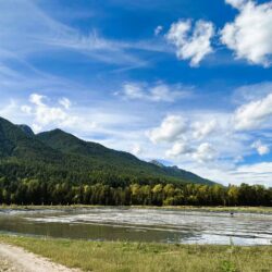
July 13, 2026
July 13, 2026
July 13, 2026
July 12, 2026
July 10, 2026
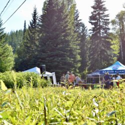
July 8, 2026

Wed, Jul 15

Wed, Jul 15
Thu, Jul 16

Thu, Jul 16

Thu, Jul 16
Thu, Jul 16